Search the Community
Showing results for tags 'CRISM'.
-
Release 54 from the Mars Reconnaissance Orbiter mission includes new data for CRISM, SHARAD, and Gravity/Radio Science. The data are online at https://pds-geosciences.wustl.edu/missions/mro.
-
 August 3rd, 2020 Release 14 of MRO CRISM MTRDR (Map-projected Targeted Reduced Data Record), TER (Targeted Empirical Record), and TRDR (Targeted Reduced Data Record) browse and extras data has been loaded into ODE. This release fills in data from 2008_018 through 2008_221. See https://wufs.wustl.edu/ode/odeholdings/Mars_holdings.html for more information.
 -
This is the 14th release of CRISM MTRDR and TER data products. In addition, the volume MROCR_2102 is updated with new TRDR browse and extras data products.
-
Hi, I read in a CRISM doc that following: Is there a table/document where such minimum/maximum values can be found, or is it image dependent and has to be found individually each time ?
-
June 5th, 2020 - MRO Release 53 Loaded into ODE. - Updated MRO CRISM EDR and CDR products from September 27th, 2006 to February 9th, 2020 - Updated MRO CRISM DDR products from September 27th, 2006 to February 8th, 2020 - Updated MRO CRISM TRDR products from September 27th, 2006 to February 8th, 2020 - Updated MRO raw gravity data products released through May 3rd, 2020 - Updated SHARAD Radargram data products released through November 18th, 2019 (orbits through 62399) - Updated MRO MCS EDR, RDR and DDR products from September 15th, 2006 to January 31st, 2020 - Updated MRO CTX EDR products from August 30th, 2006 to December 1st, 2019 - Updated MRO HiRISE EDR, RDR, and anaglyph products released through April 30th (Orbit 64499), 2020 Please see ODE Mars Holdings – https://wufs.wustl.edu/ode/odeholdings/Mars_holdings.html
-
Hi, I am working with CRISM data on the McLaughlin Crater . I have downloaded following IR dataset images FRT0000CB488_07_IF166L_TRR3 FRT000139F7_07_IF166L_TRR3 FRT000247A0_07_IF166L_TRR3 HRS00006AC4_07_IF175L_TRR3 FRS00029E22_01_IF168L_TRR3 FRS0002B4DA_01_IF168L_TRR3 FRS0002C9DC_01_IF168L_TRR3 FRS0002DB50_01_IF168L_TRR3 FRS0002EF79_01_IF168L_TRR3 FRS0002FF3C_01_IF168L_TRR3 FRS0003134A_01_IF168L_TRR3 FRS00035729_01_IF168L_TRR3 FRS0003640C_01_IF168L_TRR3 FRS0003705A_01_IF168L_TRR3 FRT00009CAE_07_IF166L_TRR3 FRT0000A27C_07_IF166L_TRR3 FRT0000A5AA_07_IF166L_TRR3 FRT0000C42E_07_IF166L_TRR3 FRT0000C6AF_07_IF166L_TRR3 as well as those VNIR images: hsv0001bf65_01_if209s_trr3 hsv0001e87c_01_if209s_trr3 hsv0002e57c_01_if209s_trr3 hsv0003f9e0_01_if209s_trr3 hsv00043b25_07_if209s_trr3 hsv000293cf_01_if209s_trr3 hsv000412d4_03_if209s_trr3 hsv000478c2_03_if209s_trr3 hsv0002003a_01_if209s_trr3 hsv0002246d_03_if209s_trr3 hsv0003793e_01_if209s_trr3 What would be the steps needed to process those images? As far as I understood I need to 1) Convert PDS to CAT ( is it needed ? ) before loading image into Envi 1) ATM correction ( for VNIR images only photometric correction) 2) CIRRUS ( despike + destripe) 3) MRO CRISM remove stripes 4) Flatten summary products ( what does it do ? is it necessary ? ) 5) Apply crism bad band list Are the above steps correct/enough/in the correct order , and is there a script ( IDL whatever ) to process thos images as a batch task ? I am doing a geological map of the McLaughlin crater, using crism's "rock.sli" spectral library to map the geological units. Can this library be used with VNIR data, or only with IR data ? Thanks Ralph Vidal
-
March 3rd, 2020 - MRO Release 52 Loaded into ODE. - Updated MRO CRISM EDR and CDR products from September 27th, 2006 to November 9th, 2019 - Updated MRO CRISM DDR products from September 27th, 2006 to November 8th, 2019 - Updated MRO CRISM TRDR products from September 27th, 2006 to November 8th, 2019 - Updated MRO raw gravity data products released through October 26th, 2019 - Updated SHARAD Radargram data products released through August 9th, 2019 (orbits through 61097) - Updated MRO MCS EDR, RDR and DDR products from September 15th, 2006 to October 31st, 2019 - Updated MRO CTX EDR products from August 30th, 2006 to August 21st, 2019 - Updated MRO HiRISE EDR, RDR, anaglyph and DTM products released through February 4th (Orbit 63399), 2020 Please see ODE Mars Holdings – https://wufs.wustl.edu/ode/odeholdings/Mars_holdings.html
-
Hi, I am trying to use the MSP I/F data from CRISM for spectral analysis. It is of the third version (TRR3). I followed these steps: 1)Convert PDS file to CAT file 2)Photometric correction (divide by cosine of incidence angle) 3)Atmospheric correction using the Volcano Scan technique (default 61C4) However I am yet to do the destriping and despiking for the data cube. I am not sure of which option to use - CIRRUS clean cube or the MRO CRISM Remove Stripes. Additionally, I also found that in one of the workshop presentations, it is not necessary to go for destriping and despiking for TRR3 products. Has anyone here processed MSP TRR3 data or have resources that explain the necessary pre-processing required?
-
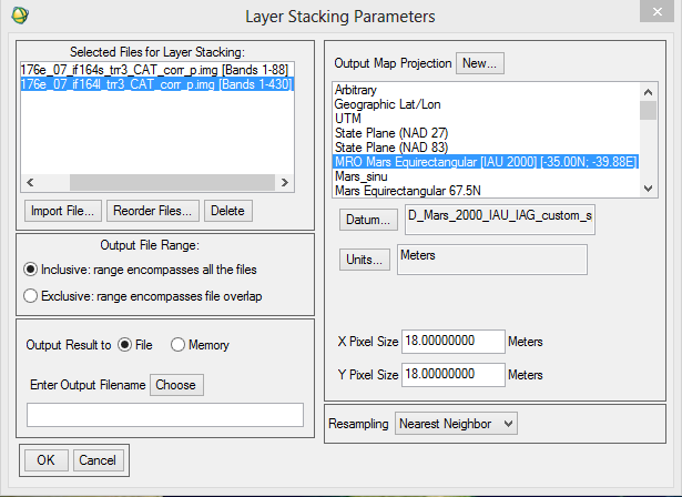
Hello My name is Vidyesh Sathe, I am actually working on my Dissertation in Planetary Geology, I am pretty new to Crism Data Set and Analysis of Crism Data. I am using Data set which is frt0001176e_07_if164ds_trr3.img and frt0001176e_07_if164l_trr3.img, i am using both VNIR And IR data. sir I followed the process given in CRISM Demonstration: Data Access, Processing, and Analysis - 3rd Planetary Data Workshop 2012, After pre-processing given in presentation, I wanted to Combine both VNIR and IR data. so i followed standard Envi process which is, Envi-Basic Tool-Layer stacking I imported both map-projected images of VNIR(S) and IR(L). But as the result the image was completely Black but the information was present(Spectra information from 0.5-3.9) I will be really grateful if you can explain to me what i am doing wrong, and what should I do to correctly project the image. Thank You.
.thumb.png.33b8f16d9db3d6a53d910500f2f02e46.png)
-
December 1st, 2019 - MRO Release 51 Loaded into ODE. - Updated MRO CRISM EDR and CDR products from September 27th, 2006 to August 9th, 2019 - Updated MRO CRISM DDR products from September 27th, 2006 to August 8th, 2019 - Updated MRO CRISM TRDR products from September 27th, 2006 to August 8th, 2019 - Updated MRO raw gravity data products released through October 30th, 2019 - Updated MRO SHARAD EDR products from December 6th, 2006 to May 11th, 2019 (orbits through 59950) - Updated SHARAD Radargram data products released through May 23rd, 2019 (orbits through 60098) - Updated MRO MCS EDR, RDR and DDR products from September 15th, 2006 to July 31st, 2019 - Updated MRO CTX EDR products from August 30th, 2006 to May 31st, 2019 - Updated MRO HiRISE EDR, RDR, anaglyph and DTM products released through November 3rd (Orbit 62199), 2019 Please see ODE Mars Holdings – https://wufs.wustl.edu/ode/odeholdings/Mars_holdings.html
-
November 4th, 2019 Release 13 of MRO CRISM MTRDR (Map-projected Targeted Reduced Data Record), TER (Targeted Empirical Record), and TRDR (Targeted Reduced Data Record) browse and extras data has been loaded into ODE. This release fills in data from 2007_278 through 2008_221. See https://wufs.wustl.edu/ode/odeholdings/Mars_holdings.html for more information.
-
This is the thirteenth release of CRISM MTRDR and TER data products. In addition, the volume MROCR_2102 is updated with new TRDR browse and extras data products.
-
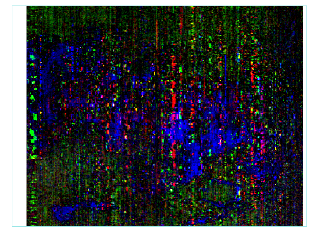
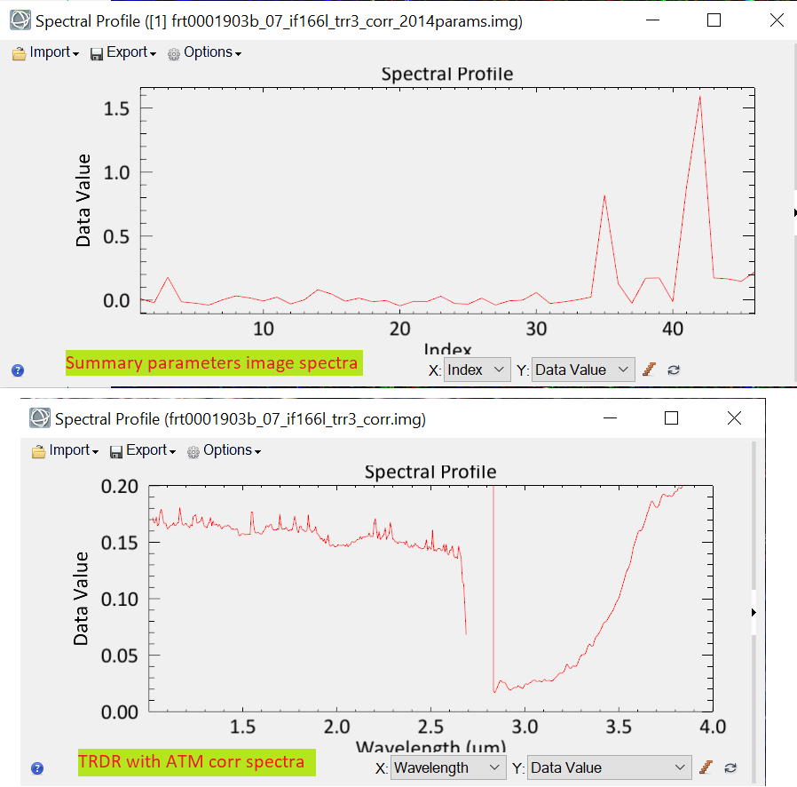
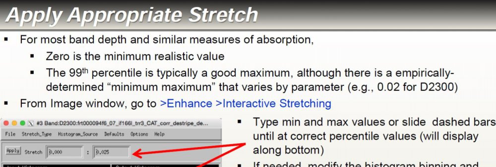
Hi community, I'm working with ENVI 5.3 + IDL coupled with CAT 7.4 trying to process TRDR images (.trr3). I'm based primarly on the CRISM data processing workshop from 2012 and 2017 and my worksteps are as follows: 1.- Apply the ATM corrections with CAT to the images 2.- Apply de map projection fo the image 3.- Obtain the summary parameters image Nevertheless, I have certain doubts about this, so I would be very grateful if you can provide me some help please. My questions are: - Should I obtain the summary parameters and then apply the map projection or it is the opposite? - It is necessary the "ratioing" for the spectra and use the "Flatten summary parameters" option?. I've seen a post where its says that is enough the "Continuum Removed" option - How can i obtain a better resolution for the summary parameters image?. I've seen very good resolution images from papers that doesn't look like what I have obtaining (img_1) - When I create the summary parameters image the spectra doesn't look like the TRDR pure image because the data values change. Does that mean that I have to use the spectra from the TRDR and the summary parameters image is just like a "color guide" fot the mineral phases? (img_2) Finally, how can I use the summary parameters properly and elaborate mineralogical maps from they? Any help will be very appreciated, thank you. Wladimir wladimiracevedo@udec.cl img_1: The resolution that I'm getting from the summary parameters image after the custom stretch img_2: Spectra for the summary parameters image vs the original TRDR corrected image from the same pixel on both.


-
September 1st, 2019 - MRO Release 50 Loaded into ODE. - Updated MRO CRISM EDR and CDR products from September 27th, 2006 to May 9th, 2019 - Updated MRO CRISM DDR products from September 27th, 2006 to May 8th, 2019 - Updated MRO CRISM TRDR products from September 27th, 2006 to May 8th, 2019 - Updated MRO raw gravity data products released through August 4th, 2019 - Updated SHARAD Radargram data products released through February 11th, 2019 (orbits through 58798) - Updated MRO MCS EDR, RDR and DDR products from September 15th, 2006 to April 30th, 2019 - Updated MRO CTX EDR products from August 30th, 2006 to March 1st, 2019 - Updated MRO HiRISE EDR, RDR, anaglyph and DTM products released through July 31st (Orbit 60999), 2019 Please see ODE Mars Holdings – https://wufs.wustl.edu/ode/odeholdings/Mars_holdings.html
-
July 22nd, 2019 Release 12 of MRO CRISM MTRDR (Map-projected Targeted Reduced Data Record), TER (Targeted Empirical Record), and TRDR (Targeted Reduced Data Record) browse and extras data has been loaded into ODE. This release fills in data from 2007_222 through 2008_051. See https://wufs.wustl.edu/ode/odeholdings/Mars_holdings.html for more information.
-
June 3rd, 2019 - MRO Release 49 Loaded into ODE. - Updated MRO CRISM EDR and CDR products from September 27th, 2006 to February 9th, 2019 - Updated MRO CRISM DDR products from September 27th, 2006 to February 9th, 2019 - Updated MRO CRISM TRDR products from September 27th, 2006 to February 9th, 2019 - Updated MRO raw gravity data products released through May 5th, 2019 - Updated MRO SHARAD EDR products from December 6th, 2006 to October 15th, 2018 (orbits through 57279) - Updated SHARAD Radargram data products released through October 15th, 2018 (orbits through 57279). - Updated MRO MCS EDR, RDR and DDR products from September 15th, 2006 to January 31st, 2019 - Updated MRO HiRISE EDR, RDR, anaglyph and DTM products released through April 27th (Orbit 59772), 2019 Please see ODE Mars Holdings – https://wufs.wustl.edu/ode/odeholdings/Mars_holdings.html
-
April 15th, 2019 Release 11 of MRO CRISM MTRDR (Map-projected Targeted Reduced Data Record), TER (Targeted Empirical Record), and TRDR (Targeted Reduced Data Record) browse and extras data has been loaded into ODE. This release fills in data from 2006_343 through 2008_039. See https://wufs.wustl.edu/ode/odeholdings/Mars_holdings.html for more information.
-
This is the eleventh release of CRISM MTRDR and TER data products. In addition, the volumes MROCR_2101 and MROCR_2102 are updated with new TRDR browse and extras data products.
-
March 4th, 2019 - MRO Release 48 Loaded into ODE. - Updated MRO CRISM EDR and CDR products from September 27th, 2006 to October 15th, 2018 - Updated MRO CRISM DDR products from September 27th, 2006 to October 15th, 2018 - Updated MRO CRISM TRDR products from September 27th, 2006 to October 15th, 2018 - Updated MRO raw gravity data products released through August 8th, 2018 - Updated MRO MCS EDR, RDR and DDR products from September 15th, 2006 to October 15th, 2018 - Updated MRO CTX EDR products from August 30th, 2006 to August 31st, 2018 - Updated MRO HiRISE EDR, RDR, anaglyph and DTM products released through February 3rd (Orbit 58699), 2019 - SHARAD EDRs and radargrams are delayed and will be loaded into ODE as soon as they are released. Please see ODE Mars Holdings – https://wufs.wustl.edu/ode/odeholdings/Mars_holdings.html
-
December 6th, 2018 - MRO Release 47 Loaded into ODE. - Updated MRO CRISM EDR and CDR products from September 27th, 2006 to August 9th, 2018 - Updated MRO CRISM DDR products from September 27th, 2006 to August 8th, 2018 - Updated MRO CRISM TRDR products from September 27th, 2006 to August 8th, 2018 - Updated MRO raw gravity data products released through May 8th, 2018 - Updated MRO SHARAD EDR products from December 6th, 2006 to May 14th, 2018 (orbits through 55279) - Updated SHARAD Radargram data products released through April 20th, 2018 (orbits through 54998) - Updated MRO MCS EDR, RDR and DDR products from September 15th, 2006 to July 31st, 2018 - Updated MRO CTX EDR products from August 30th, 2006 to May 31st, 2018 - Updated MRO HiRISE EDR, RDR, anaglyph and DTM products released through November 1st (Orbit 57499), 2018 Please see ODE Mars Holdings – https://wufs.wustl.edu/ode/odeholdings/Mars_holdings.html
-
November 14th, 2018 Release 10 of MRO CRISM MTRDR (Map-projected Targeted Reduced Data Record), TER (Targeted Empirical Record), and TRDR (Targeted Reduced Data Record) browse and extras data has been loaded into ODE. This release fills in data from 2007_132 through 2007_309. See https://wufs.wustl.edu/ode/odeholdings/Mars_holdings.html for more information.
-
This is the tenth release of CRISM MTRDR and TER data products. In addition, the volumes MROCR_2101 and MROCR_2102 are updated with new TRDR browse and extras data products.
-
September 4th, 2018 - MRO Release 46 Loaded into ODE. - Updated MRO CRISM EDR and CDR products from September 27th, 2006 to May 9th, 2018 - Updated MRO CRISM DDR products from September 27th, 2006 to May 8th, 2018 - Updated MRO CRISM TRDR products from September 27th, 2006 to May 8th, 2018 - Updated MRO raw gravity data products released through November 1st, 2018 - Updated MRO SHARAD EDR products from December 6th, 2006 to February 15th, 2018 (orbits through 54168) - Updated SHARAD Radargram data products released through February 9th, 2018 (orbits through 54099). - Updated MRO MCS EDR, RDR and DDR products from September 15th, 2006 to April 30th, 2018 - Updated MRO CTX EDR products from August 30th, 2006 to February 15th, 2018 - Updated MRO HiRISE EDR, RDR, anaglyph and DTM products released through August 1st (Orbit 56314), 2018 Please see ODE Mars Holdings – https://wufs.wustl.edu/ode/odeholdings/Mars_holdings.html
-
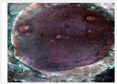
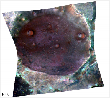
Hello, I am currently working with the CRISM Data in Matlab and when I load it, the data is always saved in a rectangular matrix. But since I need the original shape, I need to transform the cube data into it's original form. I have two screenshots how it should look like. I have also been able to read out the DDR file, but I can't find anything on the web on how to use that data. I would appreciate it if someone could help me further regarding this.
-
July 27th, 2018 Release 9 of MRO CRISM MTRDR (Map-projected Targeted Reduced Data Record), TER (Targeted Empirical Record), and TRDR (Targeted Reduced Data Record) browse and extras data has been loaded into ODE. This release fills in data from 2006_315 through 2007_116. See https://wufs.wustl.edu/ode/odeholdings/Mars_holdings.html for more information.


.png.2b590320d4e91bec8444dcfaa80b7b0d.png)