June Wang
-
Posts
587 -
Joined
-
Last visited
Content Type
Profiles
Forums
Downloads
Blogs
Everything posted by June Wang
-
July 9, 2021 – MRO HiRISE Updates - MRO HiRISE EDR, RDR, DTM and Anaglyph data products released through June 1, 2021 (Orbit 69599) New data available through below links ODE product search page: https://ode.rsl.wustl.edu/mars/indexproductsearch.aspx ODE map search page: https://ode.rsl.wustl.edu/mars/indexMapSearch.aspx ODE data holdings page: https://ode.rsl.wustl.edu/odeholdings/Mars_holdings.html
-
Viking Orbiter image data missing or not loading?
June Wang replied to Mathers99's topic in For data users
Hi Matt, I am not sure if you have the software ENVI, which is a commercial software and needs a license. ENVI works pretty well with most of the PDS IMG data. If you don't have ENVI, NASAView (https://pds.nasa.gov/tools/about/pds3-tools/nasa-view.shtml) is a free tool to have a quick look of a PDS IMG data. Also, you can use the free software package GDAL (https://www.gdal.org/) to convert the IMG files into other format such as GeoTiffs, JPG, PNG, etc. Here is a link to a similar post on our PDS Geosciences Node forum: https://geoweb.rsl.wustl.edu/community/index.php?/topic/1252-opening-file-formats/&tab=comments#comment-2374 Please let me know if you have additional questions. Thanks, June -
Viking Orbiter image data missing or not loading?
June Wang replied to Mathers99's topic in For data users
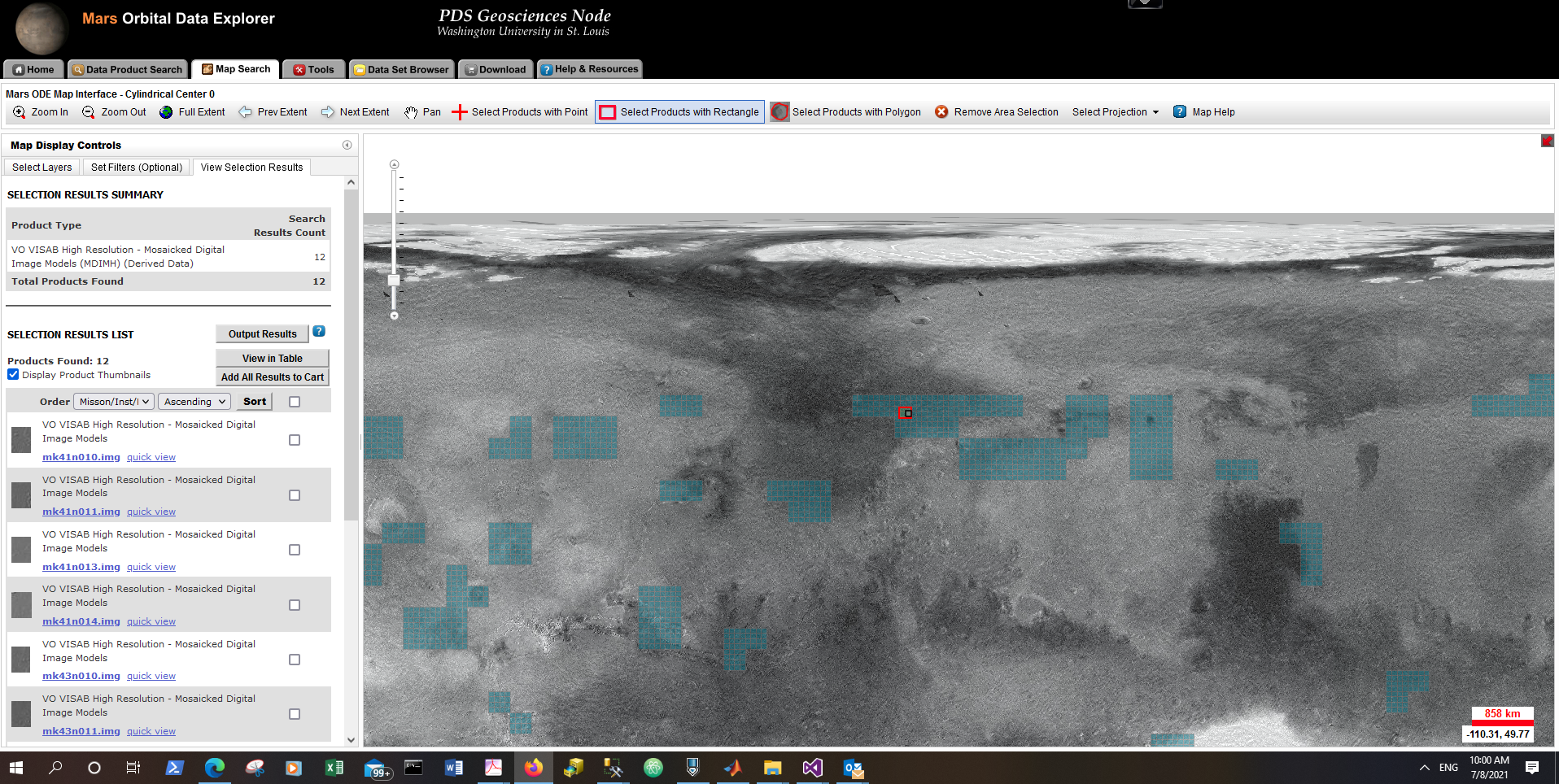
Hi Matt, if I understand correctly, do you mean you can see the footprints of the dataset, "High Resolution - Mosaicked Digital Image Models (MDIMH)" on the map, but not the context of image on the map? This is true with current version of ODE. It locates a product on a global mosaic by overlaying its footprint in the map, but doesn't support visualization of the context of an image on a basemap. If you want to look at the details of the image, first, find your region of interest, then you can draw a point, rectangle or polygon with the tools on the top of the map interface. Please see those tools in the attached "Capture_tools.PNG". You will find a yellow popup on the top left of the map. Click the yellow pop-up, ODE search results will be displayed on a left panel of the map. The interface is similar to the attached "Capture_results.PNG" which is an example of my search of VISAB data by drawing an rectangle on the map. You can see the thumnail of each VISAB product. If you are interested in any of the product, click the product ID will bring you to a product detail page with addition information and more detailed browse. We recently made a pre-recorded video for the 5th Planetary Data Workshop and 2nd Planetary Science Informatics & Data Analytics Meeting. The video gave an brief introduction of ODE and give a short demo for locating and downloading data. There was some coverage of map-based search near the end of the video recording. Please take a look at the video. If you still need help to access the Viking Orbiter VISAB data, I can schedule a zoom session with you. Thanks, June

-
July 7th, 2021 - Mars Odyssey Release 76 Data Updates - Loaded NS and HEND raw and derived data into ODE through December 31st, 2020 - Updated THEMIS standard raw (IREDR, VISEDR), calibrated (IRRDR, VISRDR), derived (IRBTR, VISABR) data products from February 19th, 2002 to November 29th, 2020 - Updated THEMIS Projected Data Products volume (ODTGEO), including special projected (IRGEO2, VGEO2) and projected derived (IRPBT2, VISALB) data products from September 28th, 2013 to November 29th, 2020 New data available through below links ODE product search page: https://ode.rsl.wustl.edu/mars/indexproductsearch.aspx ODE map search page: https://ode.rsl.wustl.edu/mars/indexMapSearch.aspx ODE data holdings page: https://ode.rsl.wustl.edu/odeholdings/Mars_holdings.html
-
June 23rd, 2021 Updated LOLA RDR query tool database from July 13th, 2009 to May 3rd, 2021
-
June 18th, 2021 - LRO Release 46 has been loaded into ODE. Updated LAMP EDR and RDR products from July 6th, 2009 to March 16th, 2021 Updated LEND EDR_SCI, EDR_HK, RDR_RSCI, and RDR_CHK products from June 18th, 2009 to March 14th, 2021 Updated LEND RDR_DLD and RDR_DLX products from June 27th, 2009 to December 14th, 2020 Updated Diviner EDR products from July 5th, 2009 to March 16th, 2021 Updated LROC EDR, CDR and RDR products from June 30th, 2009 to August 15th, 2020 Loaded Mini-RF new Version 3 Bistatic radar data products (EDR, RDR, and DDR) from January 28th, 2019 to August 25th, 2020 Updated LOLA EDR products from June 18th, 2009 to May 3rd, 2021 Updated LOLA RDR products from July 13th, 2009 to May 3rd, 2021 In Progress LOLA RDR query tool database from July 13th, 2009 to May 3rd, 2021 New data available through below links ODE product search page: https://ode.rsl.wustl.edu/moon/indexproductsearch.aspx ODE map search page: https://ode.rsl.wustl.edu/moon/indexMapSearch.aspx Please see ODE Lunar Holdings - https://ode.rsl.wustl.edu/odeholdings/Moon_holdings.html Note: The release of Diviner RDR products has been delayed in order to correct a data processing error recently discovered. See errata.txt on the Diviner RDR volume for details.
-
June 9th, 2021 SHARAD EDRs and RDRs from SHARAD Operations for MRO Release 57 are now loaded into ODE, with data coverage from August 16, 2020 to November 7, 2020.
-
June 7th, 2021 Release 17 of MRO CRISM MTRDR (Map-projected Targeted Reduced Data Record), TER (Targeted Empirical Record), and TRDR (Targeted Reduced Data Record) browse and extras data has been loaded into ODE. This release fills in data from 2008_222 through 2009_116. New data available through below links ODE product search page: https://ode.rsl.wustl.edu/mars/indexproductsearch.aspx ODE map search page: https://ode.rsl.wustl.edu/mars/indexMapSearch.aspx See https://ode.rsl.wustl.edu/odeholdings/Mars_holdings.html for more information.
-
June 7th, 2021 - MRO Release 57 Loaded into ODE. - Updated MRO CRISM EDR and CDR products from September 27th, 2006 to February 9th, 2021 - Updated MRO CRISM DDR products from September 27th, 2006 to February 8th, 2021 - Updated MRO CRISM TRDR products from September 27th, 2006 to February 8th, 2021 - Updated SHARAD Radargram data products released through November 10th, 2020 (orbits through 66998) - Updated MRO MCS EDR, RDR and DDR products from September 15th, 2006 to January 31st, 2021 - Updated MRO CTX EDR products from August 30th, 2006 to November 30th, 2020 - Updated MRO HiRISE EDR, RDR, DTM, and anaglyph products released through May 1st (Orbit 69199), 2021 New data available through below links ODE product search page - https://ode.rsl.wustl.edu/mars/indexproductsearch.aspx ODE map search page - https://ode.rsl.wustl.edu/mars/indexMapSearch.aspx Please see ODE Mars Holdings - https://ode.rsl.wustl.edu/odeholdings/Mars_holdings.html
-
May 7, 2021 – MRO HiRISE Updates - MRO HiRISE EDR, RDR, DTM and Anaglyph data products released through April 7, 2021 (Orbit 68899) New data available through below links ODE product search page: https://ode.rsl.wustl.edu/mars/indexproductsearch.aspx ODE map search page: https://ode.rsl.wustl.edu/mars/indexMapSearch.aspx ODE data holdings page: https://ode.rsl.wustl.edu/odeholdings/Mars_holdings.html
-
May 4th, 2021 - ESA's ExoMars Trace Gas Orbiter NOMAD and CaSSIS Data Updates Loaded NOMAD (Nadir and Occultation for MArs Discovery) raw and partially processed data released on May 3, 2021 into ODE - Raw data with observation range from 2020-01-01 to 2020-11-03 (Orbit Range 9394-13156) - Partially processed data with observation range from 2020-01-01 to 2020-11-03 (Orbit Range 9394-13156) Loaded CaSSIS (Colour and Stereo Surface Imaging System) raw and partially processed data released on May 3, 2021 into ODE - Raw data with observation range from 2016-04-07 to 2020-11-03 (Orbit Range 0-13156) - Partially processed data with observation range from 2016-03-14 to 2020-11-03 (Orbit Range 0-13156) New data available through below links ODE product search page: https://ode.rsl.wustl.edu/mars/indexproductsearch.aspx ODE map search page: https://ode.rsl.wustl.edu/mars/indexMapSearch.aspx See below links for more information https://ode.rsl.wustl.edu/odeholdings/Mars_holdings.html
-
ODE - The Fourth release of Earth-based Venus Radar Data Loaded into ODE April 22nd, 2021 – The fourth release of Earth-based Venus radar data from Bruce Campbell loaded into ODE. This release contains data collected on March 31, 2001, and from May 24 - May 30, 2020. See below links for more details http://pds-geosciences.wustl.edu/missions/venus_radar/index.htm ODE product search page ODE data holdings page
-
- MRO HiRISE EDR, RDR, DTM and Anaglyph data products released through March 7, 2021 (Orbit 68499) New data available through below links ODE product search page: https://ode.rsl.wustl.edu/mars/indexproductsearch.aspx ODE map search page: https://ode.rsl.wustl.edu/mars/indexMapSearch.aspx ODE data holdings page: https://ode.rsl.wustl.edu/odeholdings/Mars_holdings.html
-
April 7th, 2021 - Mars Odyssey Release 75 Data Updates -Loaded NS and HEND raw and derived data into ODE through September 30th, 2020, including re-processed versions of all previous DND and AND products for the entire mission. -Updated THEMIS standard raw (IREDR, VISEDR), calibrated (IRRDR, VISRDR), derived (IRBTR, VISABR) data products from February 19th, 2002 to August 30th, 2020 -Updated THEMIS Projected Data Products volume (ODTGEO), including special projected (IRGEO2, VGEO2) and projected derived (IRPBT2, VISALB) data products from September 28th, 2013 to August 30th, 2020 New data available through below links ODE product search page: https://ode.rsl.wustl.edu/mars/indexproductsearch.aspx ODE map search page: https://ode.rsl.wustl.edu/mars/indexMapSearch.aspx See https://ode.rsl.wustl.edu/odeholdings/Mars_holdings.html
-
March 29th, 2021 - ESA's ExoMars Trace Gas Orbiter NOMAD and CaSSIS Data Updates Loaded NOMAD (Nadir and Occultation for MArs Discovery) raw, partially processed, and calibrated data released on March 25, 2021 into ODE - Raw data with observation range from 2020-01-01 to 2020-09-26 (Orbit Range 9394-12679) - Partially processed data with observation range from 2020-01-01 to 2020-09-26 (Orbit Range 9394-12679) - Calibrated data with observation range from 2018-04-21 to 2018-09-30 (Orbit Range 1829-3808) Loaded CaSSIS (Colour and Stereo Surface Imaging System) raw, partially processed, and calibrated data released on March 25, 2021 into ODE - Raw data with observation range from 2016-04-07 to 2020-09-25 (Orbit Range 0-12679) - Partially processed data with observation range from 2016-03-14 to 2020-09-25 (Orbit Range 0-12679) - Calibrated data with observation range from 2018-04-28 to 2020-02-22 (Orbit Range 1914-10034) New data available through below links ODE product search page: https://ode.rsl.wustl.edu/mars/indexproductsearch.aspx ODE map search page: https://ode.rsl.wustl.edu/mars/indexMapSearch.aspx See below links for more information https://ode.rsl.wustl.edu/odeholdings/Mars_holdings.html ftp://psa.esac.esa.int/pub/mirror/ExoMars2016/em16_tgo_cas/ ftp://psa.esac.esa.int/pub/mirror/ExoMars2016/em16_tgo_nmd/
-
March 29th, 2021 Updated Diviner RDR query tool database from July 5th, 2009 to December 15th, 2020
-
March 25th, 2021 SHARAD RDRs from SHARAD Operations for MRO Release 56 are now loaded into ODE, with data coverage from May 10, 2020 to August 15, 2020.
-
March 22nd, 2021 - LRO Release 45 has been loaded into ODE. Updated LAMP EDR and RDR products from July 6th, 2009 to December 15th, 2020 Updated LEND EDR_SCI, EDR_HK, RDR_RSCI, and RDR_CHK products from June 18th, 2009 to December 14th, 2020 Updated LEND RDRALD, RDR_DLD and RDR_DLX products from June 27th, 2009 to September 14th, 2020 Updated Diviner EDR and RDR products from July 5th, 2009 to December 15th, 2020 Updated LROC EDR, CDR and RDR products from June 30th, 2009 to December 15th, 2020 Updated Mini-RF Version 3 Bistatic radar data products (EDR, RDR, and DDR) from January 28th, 2019 to June 21st, 2020 Updated LOLA EDR products from June 18th, 2009 to January 26th, 2021 Updated LOLA RDR products from July 13th, 2009 to January 26th, 2021 Updated LOLA RDR query tool database from July 13th, 2009 to January 26th, 2021 In Progress Diviner RDR query tool database from July 5th, 2009 to December 15th, 2020 New data available through below links ODE product search page: https://ode.rsl.wustl.edu/moon/indexproductsearch.aspx ODE map search page: https://ode.rsl.wustl.edu/moon/indexMapSearch.aspx Please see ODE Lunar Holdings: https://ode.rsl.wustl.edu/odeholdings/Moon_holdings.html
-
March 14th, 2021 SHARAD EDRs from SHARAD Operations for MRO Release 56 are now loaded into ODE, with data coverage from May 10, 2020 to August 15, 2020.
-
March 8th, 2021 Release 16 of MRO CRISM MTRDR (Map-projected Targeted Reduced Data Record), TER (Targeted Empirical Record), and TRDR (Targeted Reduced Data Record) browse and extras data has been loaded into ODE. This release fills in data from August 9 through December 25, 2008 (2008_222 to 2008_360). New data available through below links ODE product search page: https://ode.rsl.wustl.edu/mars/indexproductsearch.aspx ODE map search page: https://ode.rsl.wustl.edu/mars/indexMapSearch.aspx See https://ode.rsl.wustl.edu/odeholdings/Mars_holdings.html for more information.
-
March 8th, 2021 - MRO Release 56 Loaded into ODE. - Updated MRO CRISM EDR and CDR products from September 27th, 2006 to November 9th, 2020 - Updated MRO CRISM DDR products from September 27th, 2006 to November 9th, 2020 - Updated MRO CRISM TRDR products from September 27th, 2006 to November 8th, 2020 - Updated SHARAD Radargram data products released through August 9th, 2020 (orbits through 65799) - Updated MRO MCS EDR, RDR and DDR products from September 15th, 2006 to October 31st, 2020 - Updated MRO CTX EDR products from August 30th, 2006 to August 31st, 2020 - Updated MRO HiRISE EDR, RDR, DTM, and anaglyph products released through February 4th (Orbit 68099), 2021 New data available through below links ODE product search page: https://ode.rsl.wustl.edu/mars/indexproductsearch.aspx ODE map search page: https://ode.rsl.wustl.edu/mars/indexMapSearch.aspx Please see ODE Mars Holdings – https://ode.rsl.wustl.edu/odeholdings/Mars_holdings.html
-
We were contacted by a user who are looking at the tectonics and gravity of the Tharsis Rise region of Mars. She mentioned that she has “run into a problem analyzing some PDS data that I can't find a way around. After many days of trial and error (which was not aided by the fact that I have very little computer science experience), I was hoping you might be able to help. I'm trying to view and analyze the GMM-3 Mars gravity models, which are .IMG files (PDS listing). I don't have access to ENVI, so I've been trying alternatives, and have had the most success with the USGS's ISIS software. Now I'm stuck getting the IMG file into an image cube format that ISIS can display and analyze using qview. The pds2isis and raw2isis applications won't work because they can only process up to 32-bit images, and these are 64-bit (label file). So far I have tried, and not had any luck with, Converting the 64-bit IMG files to 32-bit files Finding lower-quality versions of the data Finding alternatives to ISIS that could process or display the IMG files My main challenge is that I need to view the data with its original unit values in milligals. Programs like ImageJ and Photoshop can open the raw PDS image files, but it will lose the units of the raw data, replacing them with a standard grayscale with pixel values of 0-255 that are disassociated from the original data values in milligals. I had the same problem with the software NASAView. If it's relevant, what I want to do with the data is create maps and profile plots across a transect for gravity and elevation data that have the actual unit values so I will be able to include a map scale and real quantitative values on the plots.” We suggested below to use GDAL for working with MRO RSS Digital Map conversion. “GDAL would help you to translate the img data to another format, but the original PDS label defined “MAP_SCALE = "N/A" “ in the *.lbl file. GDAL probably didn’t like this and didn’t work for me in my first try. I manually changed that string to ‘’ MAP_SCALE = 3704.461337 <m/pixel>” as shown in the attached label, and run below gdal_translate commands. GDAL could read the PDS IMG data and output a Geotiff. The first command output a 64bit Geotiff, and the second command output a 32 bit Geotiff. You can read the page (https://gdal.org/programs/gdal_translate.html) to adjust the parameters for your application. gdal_translate -of GTiff D:\test\data\mro\ggmro_120_anom_100.lbl D:\test\data\mro\ggmro_120_anom_100.tif gdal_translate -ot Float32 -of GTiff D:\test\data\mro\ggmro_120_anom_100.lbl D:\test\data\mro\ggmro_120_anom_100_32.tif GDAL can be downloaded from https://gdal.org/download.html . You can also find some tutorial on the web. I usually download GDAL for my windows computer from GISInternals (https://www.gisinternals.com/release.php). If you have a windows operating system, you can try the new version of “gdal-302-1928-x64-core.msi”near the middle of the page, https://www.gisinternals.com/query.html?content=filelist&file=release-1928-x64-gdal-3-2-1-mapserver-7-6-2.zip . Double click the *.msi, the installation window will pop-up and it is straightforward.”
-
February 26th, 2021 Updated Diviner RDR query tool database from July 5th, 2009 to September 16th, 2020
-
February 10, 2021 – MRO HiRISE Updates - MRO HiRISE EDR, RDR, DTM and Anaglyph data products released through January 4, 2021 (Orbit 67699) See https://ode.rsl.wustl.edu/odeholdings/Mars_holdings.html
-
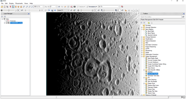
Yes, ArcGIS has better projection engine defined. And ENVI used ArcGIS projection engine in its application. The steps 3-9 you mentioned are actually based on ENVI classic interface. That blog was written years ago. After that there are many new release of ENVI, and its current version is 5.6. I don’t know which version you are using now, probably something 5.4+. If you are using a newer version of ENVI interface, one way to add the spatial reference is to find “Edit ENVI Header” under “Raster Management” in the toolbox as shown below in the right. You can add spatial reference from there. Instead of adding something for the moon, you will need to add the projection for Enceladus for this data product. When I read the label file, I noticed this data product is a CASSINI EDR data. It is archived at PDS Imaging Node under volume https://pds-imaging.jpl.nasa.gov/data/cassini/cassini_orbiter/coiss_2042/ . I would not suggest to use this EDR directly in your crater counting. If you read the “aareadme.txt” file in this volume, it said “The ISS team is not systematically performing calibration processing on the ISS EDRs.” However, their 'CALIBRATION' volumes (COISS_0xxx) “include all the necessary tools and documentation to support future users in performing their own calibration processing of the ISS EDR image datasets.” And the section “3. Data Calibration“ of “aareadme.txt” has mentioned “The Cassini ISS archive volumes contain an extras directory that is included only on the eleventh Calibration volume. This directory contains the source code for the Cassini Imaging Science Subsystem Calibration (CISSCAL) software. This software, developed by the Cassini Imaging team, allows the user to radiometrically and geometrically process the EDR-level images into higher level calibrated images.” You can also read the SIS file (https://pds-imaging.jpl.nasa.gov/data/cassini/cassini_orbiter/coiss_2042/document/edrsis.pdf) for more information. If you contact with the people at PDS Imaging Node, or people from the CASSINI team, they may provide expert help for you on this topic than I. Thanks, June