

June Wang
-
Posts
587 -
Joined
-
Last visited
Content Type
Profiles
Forums
Downloads
Blogs
Everything posted by June Wang
-
February 9, 2018 – MRO HiRISE Updates - MRO HiRISE EDR, RDR, DTM and Anaglyph data products released through January 1, 2018 (Orbit 53,599) See https://wufs.wustl.edu/ode/odeholdings/Mars_holdings.html
-
February 6th, 2018 Release 8 of MRO CRISM MTRDR (Map-projected Targeted Reduced Data Record), TER (Targeted Empirical Record), and TRDR (Targeted Reduced Data Record) browse and extras data has been loaded into ODE. This release fills in data from 2007_299 through 2008_221. See https://wufs.wustl.edu/ode/odeholdings/Mars_holdings.html for more information.
-
Hi Shyam Mohan, Both the LROC *.img data and browse images in Lunar ODE are the original data provided by the LROC team. There is nothing wrong with the data products you downloaded from ODE. It is the way how to interpret the image and the index tables. Please refer to the index.tab and index.lbl in the below link. http://lroc.sese.asu.edu/data/LRO-L-LROC-3-CDR-V1.0/LROLRC_1013/INDEX/ In index.lbl, you will find below definitions for the columns 70 to 79 for the lat &lon coordinates of the center point and 4 corner points of the image. And you can find corresponding index records from index.tab for the data product M1106080949LC. If you fill those numbers for those 4 image corners, you will see the coordinates are correct and consistent with the LROC quickmap. OBJECT = COLUMN NAME = CENTER_LATITUDE COLUMN_NUMBER = 70 DATA_TYPE = ASCII_REAL START_BYTE = 798 BYTES = 6 FORMAT = "F6.2" NOT_APPLICABLE_CONSTANT = 999.99 DESCRIPTION = "The planetocentric latitude coordinate at the center of the observation." END_OBJECT = COLUMN OBJECT = COLUMN NAME = CENTER_LONGITUDE COLUMN_NUMBER = 71 DATA_TYPE = ASCII_REAL START_BYTE = 805 BYTES = 6 FORMAT = "F6.2" NOT_APPLICABLE_CONSTANT = 999.99 DESCRIPTION = "The planetocentric longitude coordinate at the center of the observation." END_OBJECT = COLUMN OBJECT = COLUMN NAME = UPPER_RIGHT_LATITUDE COLUMN_NUMBER = 72 DATA_TYPE = ASCII_REAL START_BYTE = 812 BYTES = 6 FORMAT = "F6.2" NOT_APPLICABLE_CONSTANT = 999.99 DESCRIPTION = "Upper right latitude." END_OBJECT = COLUMN OBJECT = COLUMN NAME = UPPER_RIGHT_LONGITUDE COLUMN_NUMBER = 73 DATA_TYPE = ASCII_REAL START_BYTE = 819 BYTES = 6 FORMAT = "F6.2" NOT_APPLICABLE_CONSTANT = 999.99 DESCRIPTION = "Upper right longitude." END_OBJECT = COLUMN OBJECT = COLUMN NAME = LOWER_RIGHT_LATITUDE COLUMN_NUMBER = 74 DATA_TYPE = ASCII_REAL START_BYTE = 826 BYTES = 6 FORMAT = "F6.2" NOT_APPLICABLE_CONSTANT = 999.99 DESCRIPTION = "Lower right latitude." END_OBJECT = COLUMN OBJECT = COLUMN NAME = LOWER_RIGHT_LONGITUDE COLUMN_NUMBER = 75 DATA_TYPE = ASCII_REAL START_BYTE = 833 BYTES = 6 FORMAT = "F6.2" NOT_APPLICABLE_CONSTANT = 999.99 DESCRIPTION = "lower right longitude." END_OBJECT = COLUMN OBJECT = COLUMN NAME = LOWER_LEFT_LATITUDE COLUMN_NUMBER = 76 DATA_TYPE = ASCII_REAL START_BYTE = 840 BYTES = 6 FORMAT = "F6.2" NOT_APPLICABLE_CONSTANT = 999.99 DESCRIPTION = "lower left latitude." END_OBJECT = COLUMN OBJECT = COLUMN NAME = LOWER_LEFT_LONGITUDE COLUMN_NUMBER = 77 DATA_TYPE = ASCII_REAL START_BYTE = 847 BYTES = 6 FORMAT = "F6.2" NOT_APPLICABLE_CONSTANT = 999.99 DESCRIPTION = "lower left longitude." END_OBJECT = COLUMN OBJECT = COLUMN NAME = UPPER_LEFT_LATITUDE COLUMN_NUMBER = 78 DATA_TYPE = ASCII_REAL START_BYTE = 854 BYTES = 6 FORMAT = "F6.2" NOT_APPLICABLE_CONSTANT = 999.99 DESCRIPTION = "Upper left latitude." END_OBJECT = COLUMN OBJECT = COLUMN NAME = UPPER_LEFT_LONGITUDE COLUMN_NUMBER = 79 DATA_TYPE = ASCII_REAL START_BYTE = 861 BYTES = 6 FORMAT = "F6.2" NOT_APPLICABLE_CONSTANT = 999.99 DESCRIPTION = "Upper left longitude." END_OBJECT = COLUMN The reality is the left and right of an image is not always the west and east of real direction as you noticed, and north of image will not always be the straight up direction. It totally depends on the flight direction of the satellite and the cameras onboard the satellite. That is why you will always need to look at the index table to find the corner coordinates of the LROC data to further interpret the images. Please let me know if you still have any questions about the LROC data set. Thanks, June
-
Each Diviner RDR data product consists of two files. They are a detached PDS label and an ASCII data table file. You can open the ASCII data table directly with UltraEdit, Excel or other tools. For more information about Diviner RDR products, please see the RDR and Derived Product Software Interface Specification file @ http://pds-geosciences.wustl.edu/lro/lro-l-dlre-4-rdr-v1/lrodlr_1001/document/dp_sis.pdf . Our lunar ODE provides the DIVINER RDR Query Tool (http://ode.rsl.wustl.edu/moon/indextools.aspx?displaypage=lrodiviner) to select RDR data from the products by area. The tool returns data in a variety of formats including an ASCII table, Shapefile, and Binned Images. In addition to the RDR products, DIVINER offers a set of gridded data products (GDRs). The GDR products are RDR products assembled into global grids, with various resolution and channel combinations. I am wondering the DIVINER GDR products might meet your needs. Please see below help page for more information and let me know if you have more questions. Thanks, http://ode.rsl.wustl.edu/moon/pagehelp/quickstartguide/index.html?diviner.htm
-
Hi, I am happy to help you with your Diviner data. Would you please give me more details of the data which you can not open in ENVI, e.g., product ID and screen copy of the error message? I will take a look. thanks, June
-
ODE - Mars Odyssey Release 62 Data Loaded into ODE
June Wang replied to June Wang's topic in Announcements
January 18th, 2018 --Loaded NS and HEND raw and derived data into ODE through June 30th, 2017 See https://wufs.wustl.edu/ode/odeholdings/Mars_holdings.html. -
January 12th, 2018 –Interim Releases of MRO SHARAD EDR data loaded into ODE. Updated SHARAD EDR products from December 6th, 2006 to February 21st, 2015 (orbits through -40185) Interim Release. January 12, 2018. ---------------------------------- This release includes a redelivery of select EDR datasets due to errors in the selection of corresponding raw data files. The affected IDs are: edr2689301 edr2695502 edr2689501 edr2695801 edr2690401 edr2698501 edr2692001 edr2717901 edr2692401 edr2720601 edr2692402 edr3325001 edr2693301 edr3334301 edr2695201 edr3486101 edr2695501 Interim Release. January 4, 2018. --------------------------------- Two errors were discovered in the SHARAD Auxiliary Data Files for releases 23 through 34. The value of Orbit Number and the sign of Spacecraft Radial Velocity were incorrect. This release corrects all the errors in the affected observations. See https://wufs.wustl.edu/ode/odeholdings/Mars_holdings.html See ERRATA.TXT (http://pds-geosciences.wustl.edu/mro/mro-m-sharad-3-edr-v1/mrosh_0003/errata.txt) for more details.
-
January 12, 2018 – MRO HiRISE Updates - MRO HiRISE EDR, RDR, DTM and Anaglyph data products released through December 1, 2017 (Orbit 53,199) See https://wufs.wustl.edu/ode/odeholdings/Mars_holdings.html
-
January 11th, 2018 – The third release of Earth-based Venus radar data from Bruce Campbell loaded into ODE. This release contains data collected from August 10 - August 16, 2015 and March 21 - March 27, 2017. See below links for more details http://pds-geosciences.wustl.edu/missions/venus_radar/index.htm https://wufs.wustl.edu/ode/odeholdings/Venus_holdings.html
-
January 5th, 2018 - Mar Odyssey Release 62 THEMIS Data Updates Updated THEMIS standard data products (IREDR, IRRDR, IRBTR, VISEDR, VISRDR and VISABR data) from February 19th, 2002 to June 9th, 2017 Updated THEMIS geometry data products (IRGEO2, IRPBT2, VGEO2, and VISALB data) from September 28th, 2013 to June 9th, 2017 Release 62 of NS and HEND data is delayed. The data would be available by January 15, 2018. See https://wufs.wustl.edu/ode/odeholdings/Mars_holdings.html.
-
Jan 2, 2018 Updated Diviner RDR query tool database from July 5th, 2009 to September 15th, 2017.
-
December 19th, 2017 - LRO Release 32 has been loaded into ODE. Updated LOLA EDR products from June 18th, 2009 to September 20th, 2017 Updated LOLA RDR products from July 13th, 2009 to September 20th, 2017 Updated LAMP EDR and RDR products from July 6th, 2009 to September 15th, 2017 Updated LEND EDR_SCI, EDR_HK, RDR_RSCI, and RDR_CHK products from June 18th, 2009 to September 14th, 2017 Updated LEND RDR_DLD and RDR_DLX products from June 27th, 2009 to June 14th, 2017 Updated Diviner EDR and RDR products from July 5th, 2009 to September 16th, 2017 Updated Diviner GDR products from July 5th, 2009 to October 23rd, 2016 Updated LROC EDR, CDR and RDR products from June 30th, 2009 to September 15th, 2017 Updated LOLA RDR query tool database from July 13th, 2009 to September 20th, 2017 In Progress Diviner RDR query tool database from July 5th, 2009 to September 15th, 2017. A few LOLA GDR count gridded products have been revised; see ERRATA.TXT for details. Please see ODE Lunar Holdings - https://wufs.wustl.edu/ode/odeholdings/Moon_holdings.html
-
December 3rd, 2017 - MRO Release 43 Loaded into ODE. - Updated MRO CRISM EDR and CDR products from September 27th, 2006 to August 9th, 2017 - Updated MRO CRISM DDR products from September 27th, 2006 to July 15th, 2017 - Updated MRO CRISM TRDR products from September 27th, 2006 to July 15th, 2017 - Updated MRO raw gravity data products released through July 26th, 2017 - Updated SHARAD Radargram data products released through May 12th, 2017 (orbits through 50596). - Updated MRO MCS EDR, RDR and DDR products from September 15th, 2006 to July 31st, 2017 - Updated MRO CTX EDR products from August 30th, 2006 to May 31st, 2017 - Updated MRO HiRISE EDR, RDR, anaglyph and DTM products released through October 31st (Orbit 52799), 2017 Please see ODE Mars Holdings – https://wufs.wustl.edu/ode/odeholdings/Mars_holdings.html
-
November 11th, 2017 - THEMIS IR-reprocessed data from releases 0048, 0049, and 0050 (orbits 52300-55599) have been loaded into ODE. Please see ODE Mars Holdings – https://wufs.wustl.edu/ode/odeholdings/Mars_holdings.html
-
November 3, 2017 – MRO HiRISE Updates - MRO HiRISE EDR, RDR, DTM and Anaglyph data products released through September 30, 2017 (Orbit 52,399) See https://wufs.wustl.edu/ode/odeholdings/Mars_holdings.html
-
October 8, 2017 – MRO HiRISE Updates - MRO HiRISE EDR, RDR, DTM and Anaglyph data products released through August 30, 2017 (Orbit 51,999) - ODE also updated the “reprocessed COLOR RDR products and associated extras products for data acquired on orbits 800 - 5,999 (September 29, 2006 - November 6, 2007)” in this release. “The updated color products have improved color registration across all three bands and less aggressive noise filtering applied to make it easier for science users to identify color registration problems.” See https://wufs.wustl.edu/ode/odeholdings/Mars_holdings.html
-
October 5th, 2017 - New OMEGA EDR data for extended mission 5 loaded into ODE Updated MEX OMEGA EDR data products released through December 11th, 2016 (Orbit 16398). See https://wufs.wustl.edu/ode/odeholdings/Mars_holdings.html
-
October 4th, 2017 - Mar Odyssey Release 61 Data Updates Updated THEMIS standard data products (IREDR, IRRDR, IRBTR, VISEDR, VISRDR and VISABR data) from February 19th, 2002 to March 27th, 2017 Updated THEMIS geometry data products (IRGEO2, IRPBT2, VGEO2, and VISALB data) from September 28th, 2013 to March 27th, 2017 Loaded NS and HEND raw and derived data into ODE through March 31st, 2017 See https://wufs.wustl.edu/ode/odeholdings/Mars_holdings.html.
-
September 26th, 2017 - LRO Release 31 has been loaded into ODE Updated LOLA EDR products from June 18th, 2009 to August 3rd, 2017 Updated LOLA RDR products from July 13th, 2009 to August 3rd, 2017 Updated LOLA GDR products from July 13th, 2009 to February 2nd, 2017 Updated LAMP EDR and RDR products from July 6th, 2009 to June 15th, 2017 Updated LEND EDR_SCI, EDR_HK, RDR_RSCI, and RDR_CHK products from June 18th, 2009 to June 14th, 2017 Updated LEND RDR_ALD, RDR_DLD and RDR_DLX products from June 27th, 2009 to March 14th, 2017 Updated Diviner EDR and RDR products from July 5th, 2009 to June 16th, 2017 Updated Diviner GDR products from July 5th, 2009 to October 23rd, 2016 Updated LROC EDR, CDR and RDR products from June 30th, 2009 to June 16th, 2017 Updated LOLA RDR query tool database from July 13th, 2009 to August 3rd, 2017 Updated Diviner RDR query tool database from July 5th, 2009 to June 16th, 2017. Please see ODE Lunar Holdings - https://wufs.wustl.edu/ode/odeholdings/Moon_holdings.html
-
September 19th, 2017 - More MEX HRSC RDR Version 3 Data Loaded into ODE HRSC new radiometrically calibrated (RDR version 3) image data have been loaded into ODE, with coverage through August 17th, 2016 (Orbit 10-16000). See https://wufs.wustl.edu/ode/odeholdings/Mars_holdings.html
-
September 14th, 2017 Release 7 of MRO CRISM MTRDR (Map-projected Targeted Reduced Data Record), TER (Targeted Empirical Record), and TRDR (Targeted Reduced Data Record) browse and extras data fills in data from 2006_273 through 2012_142 has been loaded into ODE. See https://wufs.wustl.edu/ode/odeholdings/Mars_holdings.html
-
September 8th, 2017 - - - Updated MRO SHARAD EDR products from December 6th, 2006 to February 21st 2015 Please see ODE Mars Holdings – https://wufs.wustl.edu/ode/odeholdings/Mars_holdings.html
-
September 7th, 2017 - New OMEGA EDR data for extended mission 5 loaded into ODE Updated MEX OMEGA EDR data products released through June 19th, 2016 (Orbit 15799). See https://wufs.wustl.edu/ode/odeholdings/Mars_holdings.html
-
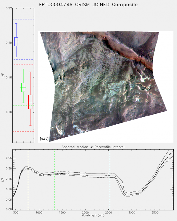
User Bobo Xi August 30, 2017 9:06 AM Dear Prof. I'm a postgraduate in xidian university,china. I'm research in the hyperspectral imge of mars at present and have downloaded the CRISM data on the PDS Geosciences Node. The datatype of the data is MTRDR and ID is “frt0000474a_07_if164j_mtr3”. Then,I have two problems with it : 1.First, I have read the "CRISM Data Product Specification", it said that the TER datas is "A spatially reconciled, full spectral range I/F targeted observation central scan image cube in the IR (L-detector) sensor space that has been corrected for geometric, photometric, atmospheric, and instrumental effects." and "MTRDRs are map-projected versions of TER data products." Then,I want to confim that does that mean that the MTRDR datas have calibrated for geometric, photometric, atmospheric, instrumental effects and map-projected ? 2. Second,the attachment of this email is the Browse Image of the MTRDR data I have dowmloaded . My question is that what is the meaning of the curve below ?In addition, I have open the MTRDR data by envi5.1 and why the spectral curve almost stay the same for each pixel in the image ? I'm feeling very confused and looking forward to your reply! Best regards! User Seelos, Frank P. August 30, 2017 1:38 PM > I want to confim that does that mean that the MTRDR datas have calibrated for geometric, photometric, atmospheric, instrumental effects and map-projected? This is correct. The only structural difference between the sensor space TER spectral image cube (the IF product) and the corresponding map-projected MTR spectral image cube is that radiometrically questionable bands have been removed from the MTR. The TER image cube has 545 bands and the MTR has 489. > Browse Image of the MTRDR ... My question is that what is the meaning of the curve below The plot shows the scene median and [5, 95] percentile envelope spectra. > the spectral curve almost stay the same for each pixel in the image The spectral variability in this scene is subdued by a relatively dusty atmosphere. The TER/MTRDR processing accounts for atmospheric gas absorptions and the relative geometric/photometric effects of aerosol scattering, but the data are top-of-atmosphere corrected I/F, not model ground reflectance. User Bobo Xi August 30, 2017 11:14 PM Hello, Thanks for your reply. but exuse me, I'm still not clearly understand my last question. In other words,if I want to make mineral classification in the image by using the material's spectral variability, does that mean that I have to use the TRDR datas and calibrate them myself by using some ground reflectance model rather than directly using the MTRDRs? User Seelos, Frank P 2017-09-01 03:40:48 If you’re interested in quantitative mineral abundance modeling then the retrieval of surface spectral reflectance through some type of surface/atmosphere separation or atmospheric correction will be required – either the TRDRs or the TERs/MTRDRs could be the starting point in this case. However, mineral identification, classification, and investigation of scene spectral variability are definitely possible with corrected I/F data – the majority of the CRISM-derived results in the literature used this type of workflow. Thanks, -Frank User Bobo Xi September 03, 2017 9:13 PM Sorry, I have been busy with something else and forgotten to write back. After seeing your reply I have totally understood, thank you very much!
-
September 5th, 2017 - Re-releasing of the THEMIS VIS-ALB data from releases 0052-0059 (orbits 56800-65599) has been loaded into ODE. Please see ODE Mars Holdings – https://wufs.wustl.edu/ode/odeholdings/Mars_holdings.html
