Chandan Kumar
-
Posts
16 -
Joined
-
Last visited
Chandan Kumar's Achievements
")
Newbie (1/14)
-
Dear PDS Geoscience Group, Greetings, I would like to download the Martian global datasets of TES products such as albedo, thermal inertia and minerals abundance in GeoTiff file format. I tried using https://www.mars.asu.edu/data/ . I am getting mainly two options i.e. PNG and VICAR. Could you please help me in getting the datasets in GeoTiff format or can help in converting the vicar file format into GeoTiff? Thank you,
-
Dear Dr. Susie, Thanks for your reply. I would like to know how to overlay global geology layer on global mola elevation data. Thanks,
-
Hi All, I am struggling in Overlay Global Mars Data (e.g Geology or GRS derived Element Concentration Maps) on MOLA elevation Data. z Can anyone help me to do this? I am attaching a snapshot for an example: I am familiar with ArcMap. Thanks,

-
MER: Sprit and Opportunity Rover APXS Data
Chandan Kumar replied to Chandan Kumar's topic in For data users
Hi Dr. VanBommel, Thank you for your valuable answer. -
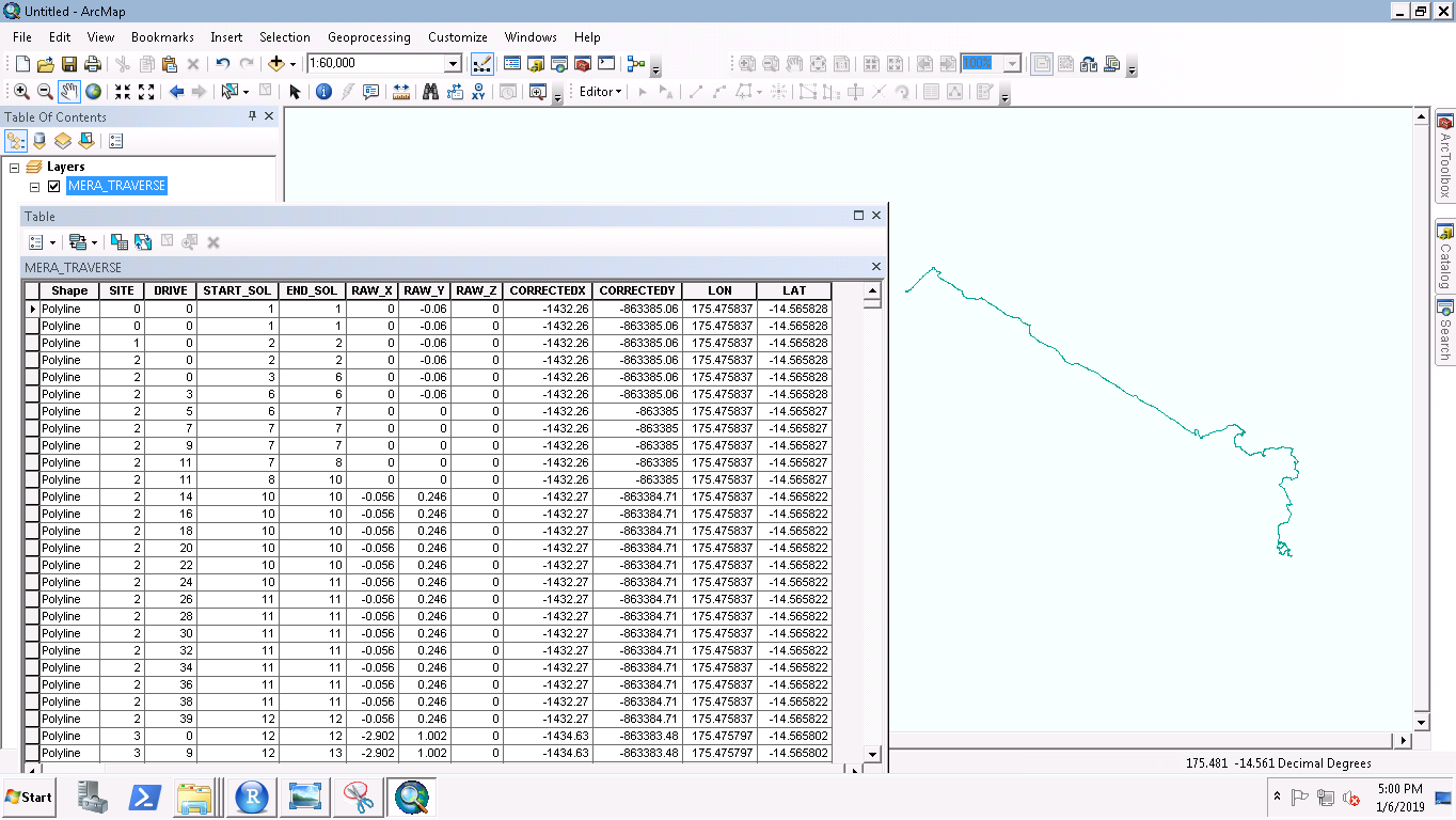
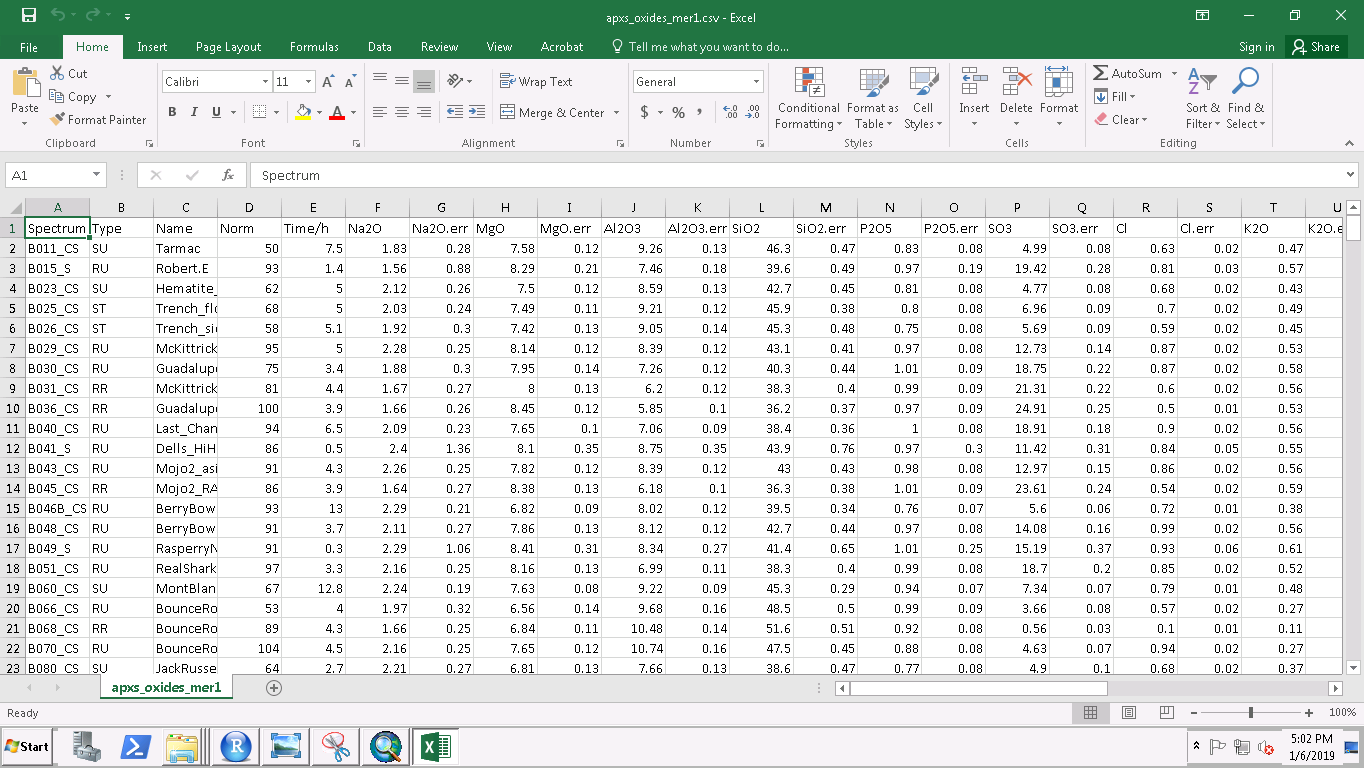
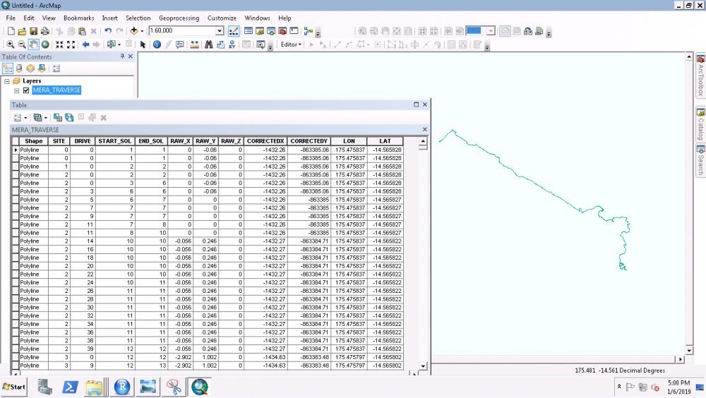
Hi, I would like to download the MER: Spirit and Opportunity Rover APXS Data with the lat/long information. I have used the NOtebook to download it and got the APXS data with element/oxide concentration. But it missing the Lat/Long information. Can anyone please help me to get this information? I also got the traverse data (shapefile) but I don't see the unique column in both the files which I can use to join the information. I am attaching the snapshot of APXS excel file and the attribute of Shapefile for the information. In the APXS data, is spectrum' name is same as Sol? Snapshot of traverse data: Snapshot of APXS Data: Thanks!

-
Dear Dr. Knodoor, Thanks for your valuable answer.
-
Dear Dr. Susie Slavney, Thanks for your valuable suggestion.
-
Hi, I would like to know where can I get the Martian Global data such as TES derived Mineralogy, inertia etc. I need the georeferenced data. I tried to download from this website(www.mars.asu.edu/data/) but the problem here is I am unable to download the georeferenced with true value. The website gives the data in PNG format which can be used for visual purpose. It would be really great If any of you can help me to get these data sets.
-
CRISM DATA PROCESSING: CRISM Ratioed I/F Corrected Spectra
Chandan Kumar replied to Chandan Kumar's topic in For data users
Thanks a lot, Dr. Ray Arvidson for your reply and suggestion. I have used the classic version of ENVI & CAT for the processing. -
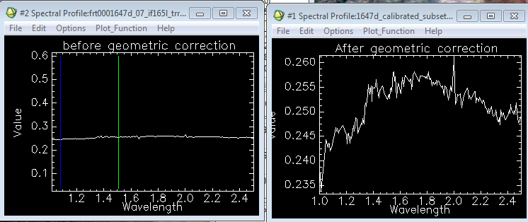
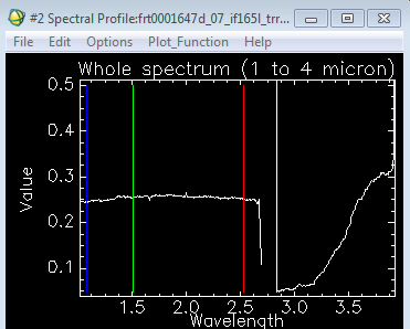
Hi, I need some help to understand the data processing of CRISM data (TRR3). I use CAT tool coupled with ENVI 5.3. I use CAT manual (workshop manual available in the website) for the processing which goes as Conversion of PDS to CAT--> Photographic and Atmospheric Correction--> Georeferencing. I observe that after the atmosphere correction spectra do not change much but once perform the geometric correction it shows changes as shown in the figure. Is obtained result correct? What is the main reason for this change? I would also like to know how to obtain ratioed spectra. I am familiar with spectra ratios but my confusion is how to choose spectra (denominator) which does not introduce errors, what region' pixels would be a better choice? Is atmospherically corrected spectrum same as I/F spectrum? All plots are atmospheric corrected. Thanks,
-
MRO CRISM data Processing: Georeferencing
Chandan Kumar replied to Chandan Kumar's topic in For data users
Hi Feng, Thanks for the solution. It works now. Thanks, -
Hi, I am getting a warning message after the georeferencing of CRISM data. It says that "MRO Custom datum D_Mars_2000_1AU_IAG_Custum_Sphere_lat00 not available. Projection may not match MTRDR. After georeferencing, when I check its details, it appears that DATAM is missing. Kindly help me to tackle this problem? Thanks,
-
Mars Odyssey, GRS instrument and CRISM
Chandan Kumar replied to Chandan Kumar's topic in For data users
Hi Scott, Thanks for your comments... -
Hi, I use CRISM data for minerals mapping (in general). Is it possible to compare with GRS instrument (HEND or other products) elements concentration data/map? I am aware of the coarser resolution of GRS products i.e. ~300 km or 5 degrees whereas CRISM spatial resolution is 18/36 m/pixel. Is GRS data available at better resolutions? or by any means can compare these two diverse resolution data results? Can we use GRS instruments data for local mapping of elements concentration despite its coarser resolution? Your comments and suggestions would be highly admired and helpful... Thanks,
-
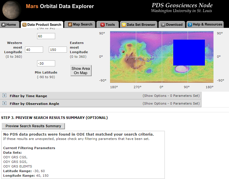
Dear Dr. Susie Slavney, Thanks for providing these details. I have some confusion in downloading from ODE Mars. When I choose the location as given below in the attached snapshot I cannot find the dataset. However, if I do not provide the location It shows a list of the dataset. My confusion is, how should I download these data set for a specific location. Could you please also suggest me the procedure of processing and interpretation of GRS instrument data? Thanks ...