June Wang
-
Posts
587 -
Joined
-
Last visited
Content Type
Profiles
Forums
Downloads
Blogs
Everything posted by June Wang
-
April 1st, 2020 - MEX HRSC new Version 3 map projected data (REFDR3) data have been loaded into ODE - HRSC new Version 3 of map projected RDR data (REFDR3) have been loaded into ODE, with coverage through November 10, 2018 (Orbit 10-18798). See https://wufs.wustl.edu/ode/odeholdings/Mars_holdings.html for a full list of data holdings in ODE.
-
March 20th, 2020 - LRO Release 41 has been loaded into ODE. Updated LAMP EDR and RDR products from July 6th, 2009 to December 15th, 2019 Updated LEND EDR_SCI, EDR_HK, RDR_RSCI, and RDR_CHK products from June 18th, 2009 to December 14th, 2019 Updated LEND RDR_DLD and RDR_DLX products from June 27th, 2009 to September 14th, 2019 Updated Diviner EDR and RDR products from July 5th, 2009 to December 16th, 2019 Updated LROC EDR, CDR and RDR products from June 30th, 2009 to December 3rd, 2019 Loaded Mini-RF new Version 3 Bistatic radar data products (EDR, RDR, and DDR) from January 28th, 2019 to June 13th, 2019 Updated LOLA EDR products from June 18th, 2009 to January 22nd, 2020 Updated LOLA RDR products from July 13th, 2009 to January 22nd, 2020 Updated LOLA RDR query tool database from July 13th, 2009 to January 22nd, 2020 Updated Diviner RDR query tool database from July 5th, 2009 to December 16th, 2019 Please see ODE Lunar Holdings - https://wufs.wustl.edu/ode/odeholdings/Moon_holdings.html
-
March 19th, 2020 - Updated MRO SHARAD EDR and RDR products from ASI for MRO Release 52 through August 17th, 2019 (orbits through 61208)
-
March 3rd, 2020 - MRO Release 52 Loaded into ODE. - Updated MRO CRISM EDR and CDR products from September 27th, 2006 to November 9th, 2019 - Updated MRO CRISM DDR products from September 27th, 2006 to November 8th, 2019 - Updated MRO CRISM TRDR products from September 27th, 2006 to November 8th, 2019 - Updated MRO raw gravity data products released through October 26th, 2019 - Updated SHARAD Radargram data products released through August 9th, 2019 (orbits through 61097) - Updated MRO MCS EDR, RDR and DDR products from September 15th, 2006 to October 31st, 2019 - Updated MRO CTX EDR products from August 30th, 2006 to August 21st, 2019 - Updated MRO HiRISE EDR, RDR, anaglyph and DTM products released through February 4th (Orbit 63399), 2020 Please see ODE Mars Holdings – https://wufs.wustl.edu/ode/odeholdings/Mars_holdings.html
-
March 3rd, 2020 - MEX HRSC new Version 3 map projected data (REFDR3) data have been loaded into ODE - HRSC new Version 3 of map projected RDR data (REFDR3) have been loaded into ODE, with coverage through September 11, 2018 (Orbit 10-18594). See https://wufs.wustl.edu/ode/odeholdings/Mars_holdings.html for a full list of data holdings in ODE.
-
February 19, 2020 A new Mercury SHBDR gravity model derived from MESSENGER radio science data are loaded into ODE. Please see below links for more information. https://pds-geosciences.wustl.edu/missions/messenger/rs.htm ODE Mercury Holdings - https://wufs.wustl.edu/ode/odeholdings/Mercury_holdings.html
-
February 19th, 2020 - MRO SHARAD RDR (ASI) backlogged data for releases 36-47 loaded into ODE MRO SHARAD derived data from the ASI (Italian Space Agency) SHARAD Ground Operations Center released covering the period May 17, 2015 - April 20, 2018 have been loaded into ODE. These time periods correspond to previous MRO releases 36-47. The SHARAD team is recovering data from deliveries that were missed due to a hiatus in ground operations between June 2012 and March 2013. See file ERRATA.TXT at https://pds-geosciences.wustl.edu/mro/mro-m-sharad-4-rdr-v1/mrosh_1004/errata.txt for more details. Please see ODE Mars Holdings – https://wufs.wustl.edu/ode/odeholdings/Mars_holdings.html
-
February 7, 2020 – MRO HiRISE Updates - MRO HiRISE EDR, RDR, DTM and Anaglyph newly released data products through January 4, 2020 (Orbit 62,999) loaded into ODE See https://wufs.wustl.edu/ode/odeholdings/Mars_holdings.html
-
January 10, 2020 – MRO HiRISE Updates - MRO HiRISE EDR, RDR, DTM and Anaglyph data products released through December 3, 2019 (Orbit 62,599) See https://wufs.wustl.edu/ode/odeholdings/Mars_holdings.html
-
Along-track stripping artifact correction and map projection
June Wang replied to Wladimir Acevedo's topic in For data users
Did you try to use ENVI mask or band calculation to filter out the black pixels? If you like, you can upload the CRISM output together with the ENVI header online. I can have a try of your data. Thanks, June -
Along-track stripping artifact correction and map projection
June Wang replied to Wladimir Acevedo's topic in For data users
Do you mean the black pixels along the edge of the image, which represent no data? If that is the "black pixels" you want to clean, in ArcGIS, when you overlain the CRISM output onto a DTM, right click the image, and choose properties. Below is the instruction to remove the background area of a raster layer using the Unique Values renderer in ArcMap. Arcscene has similar function to set the background color as transparent. Or you can google an example. I cannot use ArcGIS desktop these days due to a university license issue. People are still working on that. If you still have problem, I can send you a pic example as soon as I can access my ArcGIS desktop again. Thanks, https://desktop.arcgis.com/en/arcmap/10.3/manage-data/raster-and-images/removing-the-background-using-the-unique-values-renderer.htm June -
Along-track stripping artifact correction and map projection
June Wang replied to Wladimir Acevedo's topic in For data users
I am not quite understand your question. Do you like to know how to give a 3D view? I saw your overlain of the CRISM onto a CTX. If you overlain all the images onto a DTM, and change the terrain exaggeration factors, you will see something like above figures from different points of views. HiRiSE DTM has much higher resolution than the DTMs from HRSC and MOLA. Map resolution for a HiRISE image is about 25cm/pixel, and the HiRISE DTM is about 1m/pixel. HRSC DTMs have various resolution from 50m/pixel to 400m/pixel. Most of the products are at the resolution of ~50m/pixel, 75m/pixel, and 100m/pixel. MOLA DTM is about 500m/pixel. CTX image is about 6m/pixel. And FRT CRISM data are about 18m/pixel. Depending on your needs, the higher resolution of a DTM, the more detailed features the terrain can represent. -
January 6th, 2020 - Mars Odyssey Release 70 Data Updates Loaded NS and HEND raw and derived data (EDR, DHD, DND, AHD, and AND) into ODE through June 30th, 2019 Updated THEMIS standard data products (IREDR, IRRDR, IRBTR, VISEDR, VISRDR and VISABR data) from February 19th, 2002 to June 4th, 2019 Updated THEMIS geometry data products (IRGEO2, IRPBT2, VGEO2, and VISALB data) from September 28th, 2013 to June 4th, 2019 See https://wufs.wustl.edu/ode/odeholdings/Mars_holdings.html.
-
Along-track stripping artifact correction and map projection
June Wang replied to Wladimir Acevedo's topic in For data users
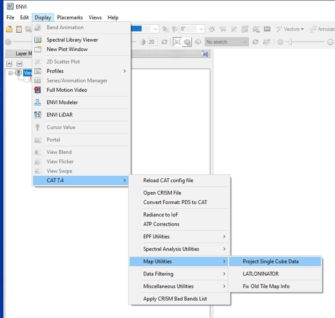
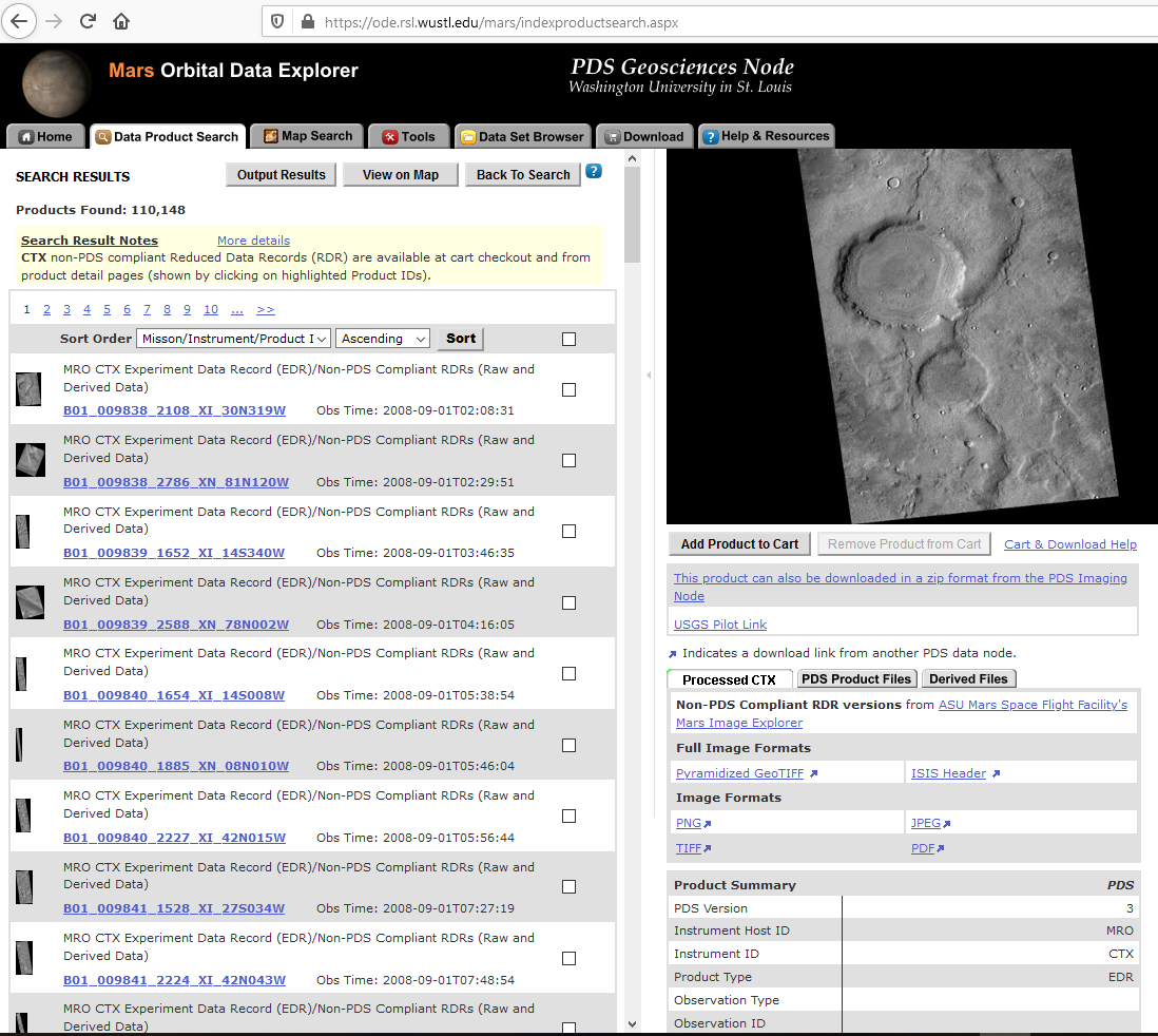
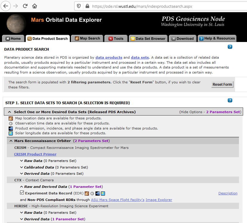
Hi Wladimir , ENVI 5.3 would also work for you. Please have a try. You can search for CTX EDR and Non-PDS Compliant RDRs through Mars ODE (https://ode.rsl.wustl.edu/mars/indexProductSearch.aspx) as shown in the attached fig1. In the data search results page (fig2), you can download the 'Pyramidized GeoTIFF' under 'Processed CTX' panel on the right. The Pyramidized GeoTIFF image has spatial reference information included in the image header. You can export a map projected CRISM image using the CAT menu function as shown in the fig3. The CRISM output can be overlain with the CTX RDR in ArcGIS. Please let me know if this doesn't work for you. Thanks, June Fig1 Fig2 Fig3

-
Along-track stripping artifact correction and map projection
June Wang replied to Wladimir Acevedo's topic in For data users
Hi Wladimir , You can download non-PDS Compliant CTX RDR data from Mars ODE(https://ode.rsl.wustl.edu/mars/indexProductSearch.aspx) or from ASU Mars Space Flight Facility's Mars Image Explorer (http://viewer.mars.asu.edu/planetview/inst/ctx/#T=0) directly. Those CTX RDR data are map projected and could be overlain with the HiRISE DTM. ArcGIS can project the data on the fly if they have different projections. I can also help if you need more assists on data registration. Thanks, June -
December 30th, 2019 Updated Diviner RDR query tool database from July 5th, 2009 to September 15th, 2019.
-
December 20th, 2019 - LRO Release 40 has been loaded into ODE. Updated LAMP EDR and RDR products from July 6th, 2009 to September 15th, 2019 Updated LEND EDR_SCI, EDR_HK, RDR_RSCI, and RDR_CHK products from June 18th, 2009 to September 14th, 2019 Updated LEND RDR_DLD and RDR_DLX products from June 27th, 2009 to June 14th, 2019 Updated Diviner EDR and RDR products from July 5th, 2009 to September 16th, 2019 Updated LROC EDR, CDR and RDR products from June 30th, 2009 to September 15th, 2019 Loaded Mini-RF new Version 3 Bistatic radar data products (EDR, RDR, and DDR) from January 28th, 2019 to February 4th, 2019 Updated LOLA EDR products from June 18th, 2009 to November 7th, 2019 Updated LOLA RDR products from July 13th, 2009 to November 7th, 2019 Updated LOLA RDR query tool database from July 13th, 2009 to November 7th, 2019 In Progress Diviner RDR query tool database from July 5th, 2009 to September 15th, 2019 Please see ODE Lunar Holdings - https://wufs.wustl.edu/ode/odeholdings/Moon_holdings.html
-
December 1st, 2019 - MRO Release 51 Loaded into ODE. - Updated MRO CRISM EDR and CDR products from September 27th, 2006 to August 9th, 2019 - Updated MRO CRISM DDR products from September 27th, 2006 to August 8th, 2019 - Updated MRO CRISM TRDR products from September 27th, 2006 to August 8th, 2019 - Updated MRO raw gravity data products released through October 30th, 2019 - Updated MRO SHARAD EDR products from December 6th, 2006 to May 11th, 2019 (orbits through 59950) - Updated SHARAD Radargram data products released through May 23rd, 2019 (orbits through 60098) - Updated MRO MCS EDR, RDR and DDR products from September 15th, 2006 to July 31st, 2019 - Updated MRO CTX EDR products from August 30th, 2006 to May 31st, 2019 - Updated MRO HiRISE EDR, RDR, anaglyph and DTM products released through November 3rd (Orbit 62199), 2019 Please see ODE Mars Holdings – https://wufs.wustl.edu/ode/odeholdings/Mars_holdings.html
-
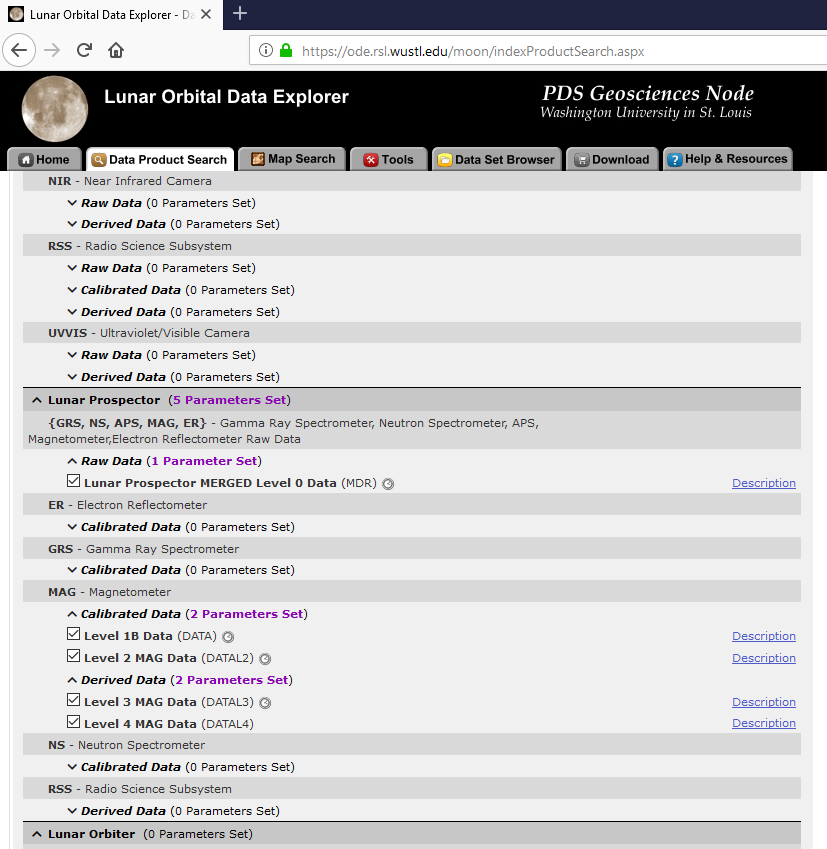
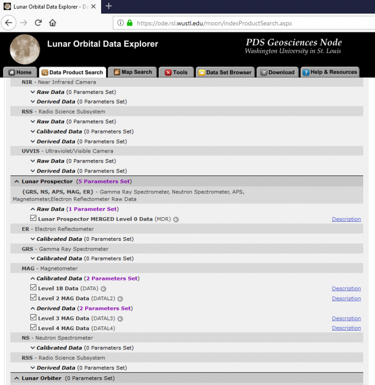
Hi Akash, PDS Geosciences node archives the Lunar Prospector MAG/ER raw data, basically the downlinked telemetry format, available at https://pds-geosciences.wustl.edu/missions/lunarp/index.htm. You can find more calibrated and derived MAG data from the PDS PPI node, https://pds-ppi.igpp.ucla.edu/mission/Lunar%20Prospector/LP/MAG#. This link describes the magnetometer experiment at PPI and provides links to the data sets that they have. Most of the raw, calibrated and derived MAG data can be searched and downloaded from the Lunar ODE web, https://ode.rsl.wustl.edu/moon/indexProductSearch.aspx. Please see below attached example data product search page, and let us know if you have any problem to access the data. Thanks, June
-
That is a very good question but hard to answer. When choosing a projection, you need to consider about how you would like to use the map and what your research interest is. No map is error free. Do you like to preserve the shape, or preserve the area, or preserve the scale, or the direction, or something else? If you want to study the mineral composition on the moon. E.g., you want to know the certain coverage of a mineral, if areas are not in true proportion, the map will give false interpolation of the data. So choosing equal-area projections will better fit this need. The size of any area on an equal-area projection map is in true proportion to its size on the moon. The decision also depends on the location of the area to be mapped. Is it a polar, mid-latitude, or equatorial region? A reasonable projection can minimize the distortion for your area of interest. Sinusoidal and Molleweide projections are both a pseudocylindrical equal-area projection. Sinusoidal projection represents the poles as points. There is no distortion at the equator and the prime meridian, but the distortion gets worse the further away from either. Scale is constant along the central meridian and all parallels. Molleweide projection represents the equator as a straight horizontal line perpendicular to a central meridian one-half its length. The 90th meridians are circular arcs and all other meridians are equally spaced elliptical arcs. The parallels are unequally spaced straight lines parallel to each other. Poles are points. Scale is true along latitudes 40°44' N and S. Distortion increases with distance from these lines and becomes severe at the edges of the projection. Equal-area is preserved for this projection but at the expense of shape distortion. Shape is not distorted at the intersection of the central meridian and latitudes 40°44' N and S. Distortion increases outward from these points and becomes severe at the edges of the projection. You may notice Simple Cylindrical, or Equirectangular, or Equidistant Cylindrical projection are used in many planetary maps. This projection is very simple to construct and it converts a globe into a Cartesian grid. When the equator is used as the standard parallel, the grid cells are perfect squares, but if any other parallel is used, the grids are rectangular. The scale is correct along the meridians and the standard parallels for this projection. Distortion increases as the distance from the standard parallels increases. The poles are represented as straight lines across the top and bottom of the map. When read below book, you can get more pros and cons for different maps projections and make your own decision. Thanks, June Snyder, John P., 1987, Map Projections, A Working Manual, U.S. Geological Survey Professional Paper 1395, 385p. http://pubs.er.usgs.gov/publication/pp1395
-
Hi Akash, no need of central_latitude for both projections. GCS_MOON_2000 is a geographic coordinate system, whose datum is the D_Moon_2000 in GIS software. The other two are major axis and minor axis in meters. Please read 'LRO Project and LGCWG White Paper' at https://lunar.gsfc.nasa.gov/library/LunCoordWhitePaper-10-08.pdf for more information.
-
Glad to hear it works for you! June
-
Hi Raj, Have you tried the docs at http://ode.rsl.wustl.edu/moon/pagehelp/quickstartguide/index.html?isros_chandrayaans_m3.htm? At the bottom of the page, you will see some additional M3 resource, including M3 ENVI User's Guide,working with M3 Data, Working with M3 L1B Data, M3 Data Tutorial and a few others. I also attached below another instruction with other example data other than yours. Please try with your own data and let me know if it works for you. Thanks, June Instruction to work with M3 level2 data.pdf
-
November 12th, 2019 - MEX HRSC new Version 3 map projected data (REFDR3) data have been loaded into ODE - HRSC new Version 3 of map projected RDR data (REFDR3) have been loaded into ODE, with coverage through May 3, 2018 (Orbit 10-18141). See https://wufs.wustl.edu/ode/odeholdings/Mars_holdings.html for a full list of data holdings in ODE.
-
November 12, 2019 – MRO HiRISE Updates - MRO HiRISE EDR, RDR, DTM and Anaglyph data products released through October 2, 2019 (Orbit 61,799) See https://wufs.wustl.edu/ode/odeholdings/Mars_holdings.html