Search the Community
Showing results for tags 'nac'.
Found 2 results
-
November 9th, 2021 - LRO LROC Release 48B has been loaded into ODE. - Loaded LRO LROC EDR and CDR data products released from 2021-07-16 to 2021-08-15. New data available through below links ODE product search page: https://ode.rsl.wustl.edu/moon/indexproductsearch.aspx ODE map search page: https://ode.rsl.wustl.edu/moon/indexMapSearch.aspx Please see ODE Lunar Holdings - https://ode.rsl.wustl.edu/odeholdings/Moon_holdings.html
-
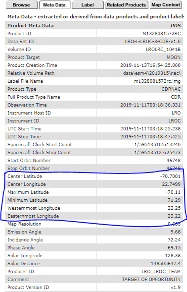
Hello all, I have downloaded the following LROC NAC CDR files from the Lunar Orbital Data Explorer Node https://ode.rsl.wustl.edu/moon/indexproductsearch.aspx M1328074531LC M1328074531RC M1328081572LC M1328081572RC M1328088614LC M1328088614RC I need to know the latitude and longitude coordinates corresponding to each of the 52224*5000 pixels. The meta data section corresponding to the results on the above link only lists the center and extreme latitude/longitude coordinates. Kindly let me know how to proceed forward. Thanks Ayushman