Search the Community
Showing results for tags 'm3'.
-
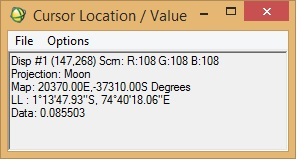
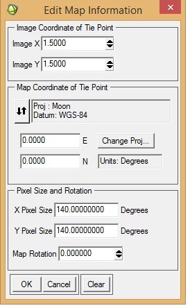
I want to georeference an M3 image (obtained via PDS) in ENVI. I was following "Assigning Map Information to PDS Images in ENVI", posted by Dr June Wang. I was able to perform most of the steps. Yet when the process is complete, it seems that the georeferencing is not correct. I have attached a couple of screenshots from the M3 image I was working with. To check the accuracy of georeferencing, I cross-checked the location from Google Moon and found that there are a lot of discrepancies between the 'georeferenced' M3 image and Google Moon. In the 'Edit Map Information' window, I entered X-pixel and Y-pixel sizes as 140. Please let me know if this is correct. When I cross-checked with Google Moon, the top of the image should have latitude as north and the bottom the image as south (also verified from LOC file of the M3 image). Please help.
-
Hi! I want to compare spectra generated from M3 with RELAB library spectra (62231, Apollo 16 landing site soil sample) using ENVI. One specific issue is, spectral library from RELAB (62231) has 451 bands, whereas M3 has 86 spectral bands. This is apparently creating a mismatch and is not allowing me to compare the two spectra. Please help!

