

June Wang
-
Posts
575 -
Joined
-
Last visited
Content Type
Profiles
Forums
Downloads
Blogs
Posts posted by June Wang
-
-
September 19th, 2017 - More MEX HRSC RDR Version 3 Data Loaded into ODE
HRSC new radiometrically calibrated (RDR version 3) image data have been loaded into ODE, with coverage through August 17th, 2016 (Orbit 10-16000).
See https://wufs.wustl.edu/ode/odeholdings/Mars_holdings.html -
September 14th, 2017
Release 7 of MRO CRISM MTRDR (Map-projected Targeted Reduced Data Record), TER (Targeted Empirical Record), and TRDR (Targeted Reduced Data Record) browse and extras data fills in data from 2006_273 through 2012_142 has been loaded into ODE.
See https://wufs.wustl.edu/ode/odeholdings/Mars_holdings.html
-
September 8th, 2017 -
- - Updated MRO SHARAD EDR products from December 6th, 2006 to February 21st 2015
Please see ODE Mars Holdings – https://wufs.wustl.edu/ode/odeholdings/Mars_holdings.html
-
September 7th, 2017 - New OMEGA EDR data for extended mission 5 loaded into ODE
Updated MEX OMEGA EDR data products released through June 19th, 2016 (Orbit 15799).
See https://wufs.wustl.edu/ode/odeholdings/Mars_holdings.html
-
User Bobo Xi
August 30, 2017 9:06 AMDear Prof. I'm a postgraduate in xidian university,china. I'm research in the hyperspectral imge of mars at present and have downloaded the CRISM data on the PDS Geosciences Node. The datatype of the data is MTRDR and ID is “frt0000474a_07_if164j_mtr3”. Then,I have two problems with it : 1.First, I have read the "CRISM Data Product Specification", it said that the TER datas is "A spatially reconciled, full spectral range I/F targeted observation central scan image cube in the IR (L-detector) sensor space that has been corrected for geometric, photometric, atmospheric, and instrumental effects." and "MTRDRs are map-projected versions of TER data products." Then,I want to confim that does that mean that the MTRDR datas have calibrated for geometric, photometric, atmospheric, instrumental effects and map-projected ? 2. Second,the attachment of this email is the Browse Image of the MTRDR data I have dowmloaded . My question is that what is the meaning of the curve below ?In addition, I have open the MTRDR data by envi5.1 and why the spectral curve almost stay the same for each pixel in the image ? I'm feeling very confused and looking forward to your reply! Best regards!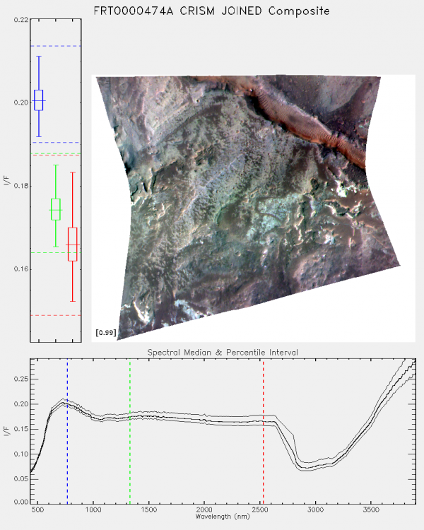
User Seelos, Frank P.
August 30, 2017 1:38 PM
> I want to confim that does that mean that the MTRDR datas have calibrated for geometric, photometric, atmospheric,  instrumental effects and map-projected?

This is correct. The only structural difference between the sensor space TER spectral image cube (the IF product) and the corresponding map-projected MTR spectral image cube is that radiometrically questionable bands have been removed from the MTR. The TER image cube has 545 bands and the MTR has 489.

> Browse Image of the MTRDR ... My question is that what is the meaning of the curve below

The plot shows the scene median and [5, 95] percentile envelope spectra.

> the spectral curve almost stay the same for each pixel in the image

The spectral variability in this scene is subdued by a relatively dusty atmosphere. The TER/MTRDR processing accounts for atmospheric gas absorptions and the relative geometric/photometric effects of aerosol scattering, but the data are top-of-atmosphere corrected I/F, not model ground reflectance.
User Bobo Xi
August 30, 2017 11:14 PMHello, Thanks for your reply. but exuse me, I'm still not clearly understand my last question. In other words,if I want to make mineral classification in the image by using the material's spectral variability, does that mean that I have to use the TRDR datas and calibrate them myself by using some ground reflectance model rather than directly using the MTRDRs?User Seelos, Frank P
2017-09-01 03:40:48If you’re interested in quantitative mineral abundance modeling then the retrieval of surface spectral reflectance through some type of surface/atmosphere separation or atmospheric correction will be required – either the TRDRs or the TERs/MTRDRs could be the starting point in this case. However, mineral identification, classification, and investigation of scene spectral variability are definitely possible with corrected I/F data – the majority of the CRISM-derived results in the literature used this type of workflow. Thanks, -FrankUser Bobo Xi
September 03, 2017 9:13 PMSorry, I have been busy with something else and forgotten to write back. After seeing your reply I have totally understood, thank you very much! -
September 5th, 2017 -
Re-releasing of the THEMIS VIS-ALB data from releases 0052-0059 (orbits 56800-65599) has been loaded into ODE.
Please see ODE Mars Holdings – https://wufs.wustl.edu/ode/odeholdings/Mars_holdings.html -
September 3rd, 2017 - MRO Release 42 Loaded into ODE.
- Updated MRO CRISM EDR and CDR products from September 27th, 2006 to May 9th, 2017
- Updated MRO CRISM DDR products from September 27th, 2006 to May 8th, 2017
- Updated MRO CRISM LDR products from July 10th, 2009 to April 29th, 2017
- Updated MRO CRISM TRDR products from September 27th, 2006 to May 8th, 2017
- Updated MRO raw gravity data products released through October 21st, 2017
- Updated SHARAD Radargram data products released through 2017-02-16 (orbits 48202 through 49499).
- Updated MRO MCS EDR, RDR and DDR products from September 15th, 2006 to April 30th, 2017
- Updated MRO CTX EDR products from August 30th, 2006 to March 1st, 2017"There is no derived gravity data in this release. Previous releases of HiRISE data cover this period, and HiRISE's next three months of data are not all available yet."
Please see ODE Mars Holdings – https://wufs.wustl.edu/ode/odeholdings/Mars_holdings.html
-
August 25, 2017 - ENVI header files have been loaded into ODE for MOLA topographic map products
ENVI header files for the MEGDR image data products have been loaded into ODE. The ENVI headers can be downloaded from the data product search result page, along with the document MOLA_ENVI.PDF, which explains the use of the header files and other methods for providing correct map projection information to ENVI and ArcGIS. See http://pds-geosciences.wustl.edu/mgs/mgs-m-mola-5-megdr-l3-v1/mgsl_300x/extras/EXTRINFO.TXT for more information.
-
August 25, 2017
ENVI header files for the MEGDR image data products have been provided in the EXTRAS directory of the MOLA MEGDR archive in http://pds-geosciences.wustl.edu/mgs/mgs-m-mola-5-megdr-l3-v1/mgsl_300x/extras/, along with the document MOLA_ENVI.PDF, which explains the use of the header files and other methods for providing correct map projection information to ENVI and ArcGIS. See EXTRINFO.TXT for more information. The ENVI header files and MOLA_ENVI.PDF can be downloaded from the data product search result page in ODE.
-
August 3, 2017 – MRO HiRISE Updates
- MRO HiRISE EDR, RDR, DTM and Anaglyph data products released through July 15, 2017 (Orbit 51,499)
See https://wufs.wustl.edu/ode/odeholdings/Mars_holdings.html
-
July 10th, 2017 - Mar Odyssey Release 60 Data Updates
Updated THEMIS standard data products (IREDR, IRRDR, IRBTR, VISEDR, VISRDR and VISABR data) from February 19th, 2002 to December 26th, 2016
Updated THEMIS geometry data products (IRGEO2, IRPBT2, VGEO2, and VISALB data) from September 28th, 2013 to December 26th, 2016
Loaded NS and HEND raw and derived data into ODE through December 31st, 2016
See https://wufs.wustl.edu/ode/odeholdings/Mars_holdings.html and http://static.mars.asu.edu/pds/errata.txt. -
July 8, 2017 – MRO HiRISE Updates
- MRO HiRISE EDR, RDR, DTM and Anaglyph data products released through June 5, 2017 (Orbit 50,899)
See https://wufs.wustl.edu/ode/odeholdings/Mars_holdings.html -
July 5th, 2017
- Updated Diviner RDR query tool database from July 5th, 2009 to March 15th, 2017.
-
June 29th, 2017 - New MRO SHARAD EDR and RDR Radargram data loaded into ODE.
Updated SHARAD EDR products from December 6th, 2006 to August 9th, 2014 (orbits through 37671) [Note: "SHARAD EDR data from the ASI operations facility have been delivered to cover the period February 9, 2013, through August 9, 2014. This is the first of several interim deliveries that will recover the backlog of data from the hiatus of operations that took place between June 2012 and March 2013." See ERRATA.TXT (http://pds-geosciences.wustl.edu/mro/mro-m-sharad-3-edr-v1/mrosh_0004/errata.txt) for details.]
Updated SHARAD Radargram data products released through November 6th, 2016 (orbits through 48196) [Note: "SHARAD RDR radargram data from the U.S. team members have been delivered to cover the period May 12, 2016, through November 6, 2016 (MRO Releases 40 and 41)." See ERRATA.TXT (http://pds-geosciences.wustl.edu/mro/mro-m-sharad-5-radargram-v1/mrosh_2001/errata.txt) for details.]See https://wufs.wustl.edu/ode/odeholdings/Mars_holdings.html
-
June 28th, 2017 - New MEX PFS Data loaded into ODE
Updated MEX PFS EDR data products released through December 31st, 2016 (Orbit 20-16467)
See https://wufs.wustl.edu/ode/odeholdings/Mars_holdings.html
-
June 25th, 2017 - MESSENGER Release 16 has been loaded into ODE. This release is the final release from the MESSENGER Project. It includes new derived products, revisions to some previously released products, and new tutorial documents. See ERRATA.TXT in the root directory of each archive volume for details.
Updated MESSENGER NS EDR and CDR products from August 12th, 2004 to April 30th, 2015
Updated MESSENGER NS DDR products from March 25th, 2011 to April 30th, 2015
Updated MESSENGER GRS CDR products from August 12th, 2004 to April 30th, 2015
Updated MESSENGER GRS RDR products from March 24th, 2011 to October 10th, 2011
Updated MESSENGER GRS DAP products from March 24th, 2011 to October 11th, 2011
Updated MESSENGER XRS EDR, CDR, and RDR products from August 30th, 2004 to April 30th, 2015
Updated MESSENGER XRS RDRMAP products from April 7th, 2011 to April 24th, 2015
Updated MESSENGER Radio Science products released through April 30th, 2015
Updated MESSENGER MLA CDR products from August 19th, 2004 to April 30th, 2015
Updated MESSENGER MLA RDR and RADR products from January 14th, 2008 to April 30th, 2015
Updated MESSENGER MLA GDR products from January 14th, 2008 to April 30th, 2015
Updated MESSENGER MASCS CDR products from August 27th, 2004 to April 30th, 2015
Updated MESSENGER MASCS DDR products from January 14th, 2008 to April 30th, 2015
Updated MESSENGER MASCS VIRDAP products from March 29th, 2011 to April 30th, 2015
Updated MESSENGER MDIS CDR products from August 19th, 2004 to April 30th, 2015
Updated MESSENGER MDIS DDR products from January 9th, 2008 to April 30th, 2015
New products for this release include:
- Regional three-color mosaics of the Caloris and B30 basin regions (MDIS RTMWAC)
- High-resolution regional DEMs (MDIS DEM)
- UVVS far-ultraviolet surface reflectance products (MASCS UVVDDR)
- Combined UVVS+VIRS spectra for the southern hemisphere (MASCS DDR)
- UVVS orbit-by-orbit summaries of exosphere observations (MASCS UVVCDR )
- Footprint products for calibrated data records (CDRs) currently at PDS (XRS RDR)
Products included in earlier releases and also included in this release (with updates to calibration or photometric correction and/or other improvements) include:
- High-, moderate- and low-incidence-angle global monochrome maps (MDIS MAPHIE, MAPHIW, and MAPLOI)
- Low-phase-angle, five-color map of the north-polar region (MDIS MAPMP5)
- Three- and eight-color global maps (MDIS MDRWAC and RDRMDR)
- Backplanes with lat/long and with incidence, emission, and phase angles (MDIS DDRNAC and DDRWAC)
- Altimeter profiles and northern-hemisphere DEM (MLA)
- UVVS calibrated products with corrections for grating shifts during both orbit and flybys, and improved calibrations for flyby data and observations of K (MASCS UVVCDR)
- UVVS advanced products based on the improved calibrated products plus additional corrections for Mg and Ca observations at low altitudes to remove light scattered from the surface (MASCS UVVS UVVDDR)
- VIRS reflectance products with improved photometric correction (MASCS VIRS VIRCDR, VIRDDR and VIRDAP)
Please see below links
ODE Mercury Holdings - https://wufs.wustl.edu/ode/odeholdings/Mercury_holdings.html
ODE Venus Holdings – https://wufs.wustl.edu/ode/odeholdings/Venus_holdings.html
All data sets in this MESSENGER release can be accessed from the PDS Data Release Summary:
https://pds.nasa.gov/tools/subscription_service/SS-20170512.shtml
-
June 23rd, 2017
- Updated LOLA RDR query tool database from July 13th, 2009 to March 28th, 2017
-
June 20th, 2017 - LRO Release 30 has been loaded into ODE.
Updated LOLA EDR products from June 18th, 2009 to March 28th, 2017
Updated LOLA RDR products from July 13th, 2009 to March 28th, 2017
Updated LAMP EDR and RDR products from July 6th, 2009 to March 15th, 2017
Updated LEND EDR_SCI, EDR_HK, RDR_RSCI, and RDR_CHK products from June 18th, 2009 to March 14th, 2017
Updated LEND RDR_ALD, RDR_DLD and RDR_DLX products from June 27th, 2009 to December 14th, 2016
Updated Diviner EDR and RDR products from July 5th, 2009 to March 15th, 2017
Updated Diviner GDR products from July 5th, 2009 to April 16th, 2016
Updated LROC EDR, CDR and RDR products from June 30th, 2009 to March 15th, 2017
In Progress LOLA RDR query tool database from July 13th, 2009 to March 28th, 2017
In Progress Diviner RDR query tool database from July 5th, 2009 to March 15th, 2017
Please see ODE Lunar Holdings - https://wufs.wustl.edu/ode/odeholdings/Moon_holdings.html
-
June 20th, 2017 - MEX HRSC new Version 3 map projected data (REFDR3) data have been loaded into ODE
- HRSC new Version 3 of map projected RDR data (REFDR3) have been loaded into ODE, with coverage through June 30, 2016 (Orbit 10-15836). The coverage now extends beyond the V2 data set. The V2 data will remain online for six months, through approximately October 25, 2017, and then it will be removed.See https://wufs.wustl.edu/ode/odeholdings/Mars_holdings.html for a full list of data holdings in ODE.
-
June 3rd, 2017 - MRO Release 41 Loaded into ODE.
- Updated MRO CRISM EDR and CDR products from September 27th, 2006 to February 9th, 2017
- Updated MRO CRISM DDR products from September 27th, 2006 to February 8th, 2017
- Updated MRO CRISM LDR products from July 10th, 2009 to December 21st, 2016
- Updated MRO CRISM TRDR products from September 27th, 2006 to February 8th, 2017
- Updated MRO raw gravity data products released through November 8th, 2016
- Updated MRO MCS EDR, RDR and DDR products from September 15th, 2006 to January 31st, 2017
- Updated MRO CTX EDR products from August 30th, 2006 to December 1st, 2016
- Updated MRO HiRISE EDR, RDR, anaglyph and DTM products released through May 5th (Orbit 50499), 2017
Please see ODE Mars Holdings – https://wufs.wustl.edu/ode/odeholdings/Mars_holdings.html
-
May 5, 2017 – MRO HiRISE Updates
- MRO HiRISE EDR, RDR, DTM and Anaglyph data products released through April 4, 2017 (Orbit 50,099)
See https://wufs.wustl.edu/ode/odeholdings/Mars_holdings.html
-
May 1st, 2017
Release 6 of MRO CRISM MTRDR (Map-projected Targeted Reduced Data Record), TER (Targeted Empirical Record), and TRDR (Targeted Reduced Data Record) browse and extras data fills in data from 2007_163 through 2008_175 has been loaded into ODE.
See https://wufs.wustl.edu/ode/odeholdings/Mars_holdings.html
-
April 26th, 2017 - MEX HRSC new Version 3 map projected data (REFDR3) data have been loaded into ODE
- HRSC new Version 3 of map projected RDR data (REFDR3) have been loaded into ODE, with coverage through August 19, 2014 (Orbit 10-13500). The coverage now extends beyond the V2 data set. The V2 data will remain online for six months, through approximately October 25, 2017, and then it will be removed.See https://wufs.wustl.edu/ode/odeholdings/Mars_holdings.html for a full list of data holdings in ODE.
-
April 18, 2017 – A new LRO Diviner data set, Global Cumulative Products (GCP), has been loaded into ODE. GCPs are compiled from Diviner nadir observations from July 5, 2009, to April 1, 2015. The data set consists of mean brightness temperatures and bolometric brightness temperatures binned at 0.5 degree latitude and longitude and 0.25 hours local time. See GCPDS.CAT (http://pds-geosciences.wustl.edu/lro/lro-l-dlre-4-rdr-v1/lrodlr_1001/catalog/gcpds.cat) and https://wufs.wustl.edu/ode/odeholdings/Moon_holdings.html for details.

ODE - LRO Release 31 Loaded into ODE
in Announcements
Posted
September 26th, 2017 - LRO Release 31 has been loaded into ODE
Updated LOLA EDR products from June 18th, 2009 to August 3rd, 2017
Updated LOLA RDR products from July 13th, 2009 to August 3rd, 2017
Updated LOLA GDR products from July 13th, 2009 to February 2nd, 2017
Updated LAMP EDR and RDR products from July 6th, 2009 to June 15th, 2017
Updated LEND EDR_SCI, EDR_HK, RDR_RSCI, and RDR_CHK products from June 18th, 2009 to June 14th, 2017
Updated LEND RDR_ALD, RDR_DLD and RDR_DLX products from June 27th, 2009 to March 14th, 2017
Updated Diviner EDR and RDR products from July 5th, 2009 to June 16th, 2017
Updated Diviner GDR products from July 5th, 2009 to October 23rd, 2016
Updated LROC EDR, CDR and RDR products from June 30th, 2009 to June 16th, 2017
Updated LOLA RDR query tool database from July 13th, 2009 to August 3rd, 2017
Updated Diviner RDR query tool database from July 5th, 2009 to June 16th, 2017.
Please see ODE Lunar Holdings - https://wufs.wustl.edu/ode/odeholdings/Moon_holdings.html