Search the Community
Showing results for tags 'Long'.
Found 2 results
-
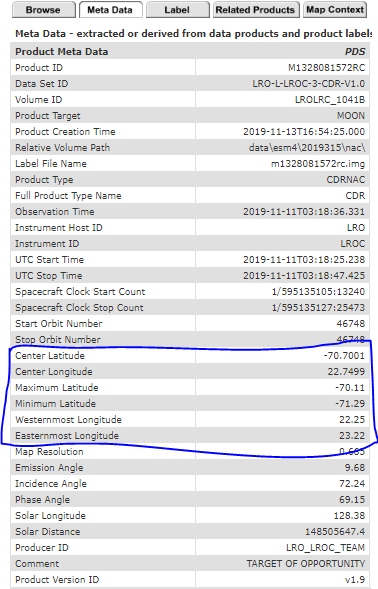
Hello all, I have downloaded the following LROC NAC CDR files from the Lunar Orbital Data Explorer Node https://ode.rsl.wustl.edu/moon/indexproductsearch.aspx M1328074531LC M1328074531RC M1328081572LC M1328081572RC M1328088614LC M1328088614RC I need to know the latitude and longitude coordinates corresponding to each of the 52224*5000 pixels. The meta data section corresponding to the results on the above link only lists the center and extreme latitude/longitude coordinates. Kindly let me know how to proceed forward. Thanks Ayushman
-
Hi, I have been looking for a CRISM image, HRL000195B9_07_IF182L_TRR3. This image is listed and displayed on the John Hopkins CRISM map website, but not available in the archive. The ODE archive does have the HRL000195B9_07_IF182S_TRR3 VNIR image, but not the IR image. There is no indication on the Johns Hopkins site that it has been superseded by another image or removed for a particular reason. Any help appreciated. Thanks in advance!

