Jennifer Ward
-
Posts
207 -
Joined
-
Last visited
Content Type
Profiles
Forums
Downloads
Blogs
Everything posted by Jennifer Ward
-
This is the eleventh release of CRISM MTRDR and TER data products. In addition, the volumes MROCR_2101 and MROCR_2102 are updated with new TRDR browse and extras data products.
-
Release 20 from the Mars Science Laboratory (Curiosity) mission includes new data for APXS, ChemCam, CheMin, DAN, and SAM. The data are online at pds-geosciences.wustl.edu/missions/msl.
-
Release 37 of Lunar Reconnaissance Orbiter data is now online at the Geosciences Node. This release includes new data acquired between September 15, 2018, and December 14, 2018, for most data sets. Data can be reached from the Geosciences Node LRO page. The Lunar Orbital Data Explorer allows searching and downloading of LRO data.
-
Release 48 from the Mars Reconnaissance Orbiter mission includes new data for CRISM and Gravity / Radio Science. The data are online at pds-geosciences.wustl.edu/missions/mro. SHARAD data are delayed and will be posted as soon as they are available.
-
Release 47 from the Mars Reconnaissance Orbiter mission includes new data for CRISM, SHARAD, and Gravity / Radio Science. The data are online at pds-geosciences.wustl.edu/missions/mro.
-
This is the tenth release of CRISM MTRDR and TER data products. In addition, the volumes MROCR_2101 and MROCR_2102 are updated with new TRDR browse and extras data products.
-
Gene, The detector temperature requirement for IR delivery to the PDS is < -145.45C. 243D0_07 is higher than that limit. MRO:DETECTOR_TEMPERATURE = -143.586 I will contact you by email to discuss this matter further. Jennifer
-
Mars Odyssey Release 65 includes new raw data (EDR), Derived Neutron Data (DND), and Derived HEND Data (DHD) products covering the period January 1 through March 31, 2018. Averaged Neutron Data (AND) and Averaged HEND Data (AHD) products cover the period January 26 to April 26, Ls 120 to Ls 165 in year 09. The data are online at the PDS Geosciences Node at http://pds-geoscienc...dyssey/grs.html.
-
Shyam, I have forwarded your questions to the PDS Imaging Node, and will post their response as soon as I receive it. Thanks, Jennifer
-
Gene, I have forwarded your question to the CRISM team and will get back to you shortly. Thank you, Jennifer
-
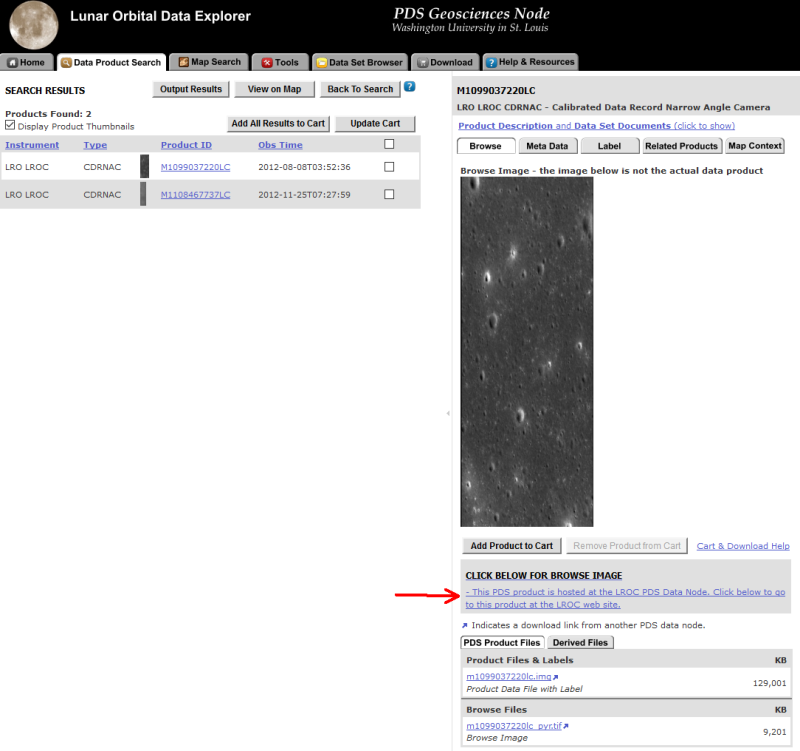
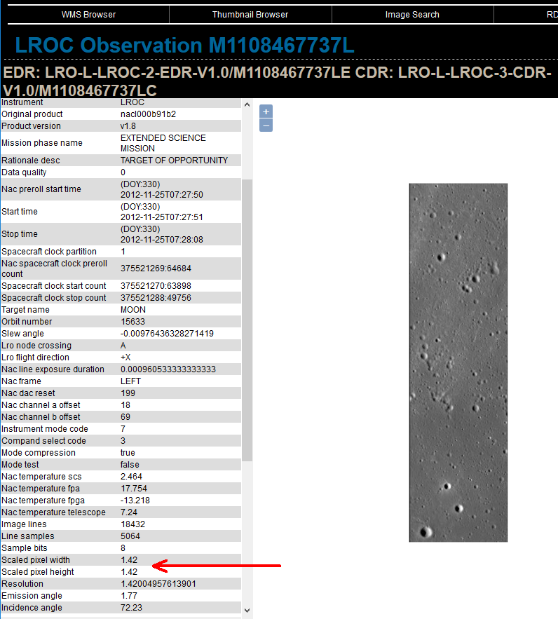
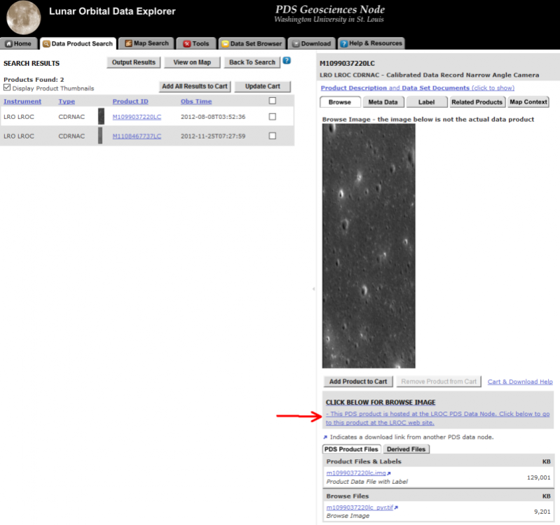
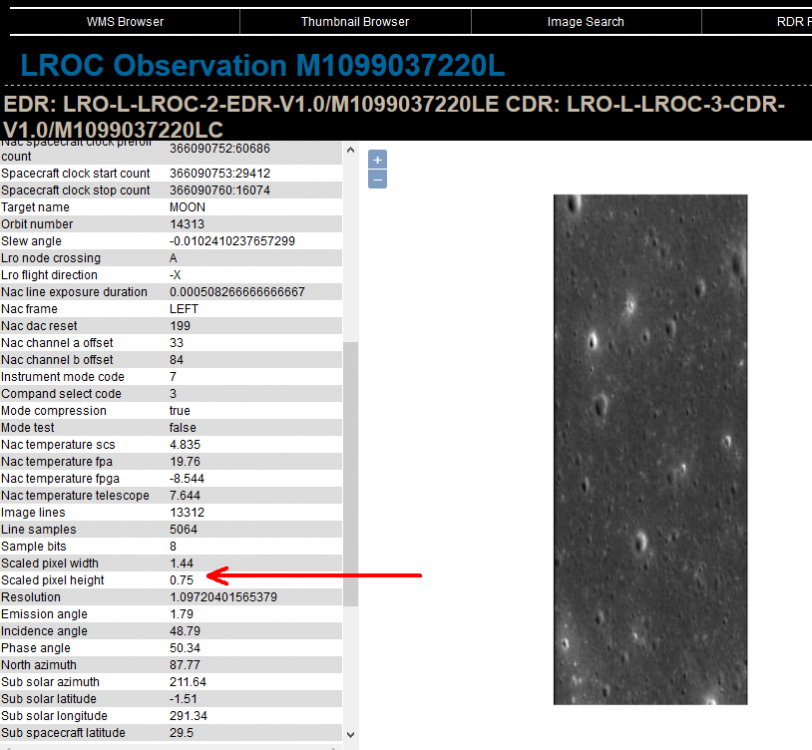
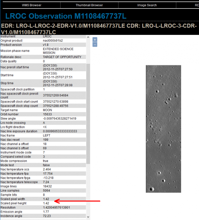
Shyam, The definition for emission angle in ODE is correct. The image where the craters look circular has the same value for scaled pixel width and height. The other image has a scaled pixel width that is twice that of the pixel height making the craters look elliptical. You can verify this by following the link in ODE to the team site and viewing the metadata there (see attached images). This metadata is also provided in the index table of the PDS archive. Please let us know if you have any more questions. PDS Geosciences Node
-
Data from Release 57 of the Mars Exploration Rover mission are now online at the PDS Geosciences Node. This release includes APXS, Atmospheric Opacity, Microscopic Imager, Navcam, Pancam, RAT, and Rover Motion Counter data from sols 4951 through 5040 for the Opportunity rover.
-
Field photographs of Amboy Crater, CA have been restored. This bundle contains a digitization of photographs taken in February 1976 by Drs. Ronald Greeley and James Iversen during field research at Amboy Crater in the Mojave Desert of southeastern California. The photographs are currently housed at the Ronald Greeley Center for Planetary Studies (RGCPS), at the Arizona State University (ASU) Regional Planetary Information Facility (RPIF). The data were provided by David Williams (ASU) and archived by the PDS Geosciences Node.
-
Release 46 from the Mars Reconnaissance Orbiter mission includes new data for CRISM, SHARAD, and Gravity / Radio Science. The data are online at pds-geosciences.wustl.edu/missions/mro.
-
This is the ninth release of CRISM MTRDR and TER data products. In addition, the volume MROCR_2101 is updated with new TRDR browse and extras data products.
-
Images collected during the Mariner Mars 1969 mission have been restored. This bundle consists of images collected during the Mariner Mars 1969 mission by the Mariner 6 and Mariner 7 spacecraft. The collections have been generated by Thomas C. Duxbury, George Mason University, and funded by the NASA Planetary Data Archiving, Restoration, and Tools program (PDART).
-
Data from Release 55 of the Mars Exploration Rover mission is now online at the PDS Geosciences Node. This release includes APXS, Atmospheric Opacity, MI, Navcam, Pancam, and Rover Motion Counter data from sols 4771 through 4860 for the Opportunity rover.
-
SHARAD EDR data from the ASI team members have been posted, covering previous MRO releases 39-42 (through Feb. 18, 2017). The team is recovering data from deliveries that were missed due to a hiatus in ground operations. See ERRATA.TXT for details. The data are available on the PDS Geosciences Node's SHARAD page.
-
SHARAD EDR data from the ASI team members have been posted, covering previous MRO releases 35-38 (through Feb. 20, 2016). The team is recovering data from deliveries that were missed due to a hiatus in ground operations. See ERRATA.TXT for details. The data are available on the PDS Geosciences Node's SHARAD page.
-
A new batch of Earth-based Venus radar data has been released on the PDS Geosciences Node web site at http://pds-geoscienc...radar/index.htm. This release contains data collected from August 10 - August 16, 2015 and March 21 - March 27, 2017. This data set contains Earth-based, polarimetric radar image data for Venus collected from 1988 onwards, using the Arecibo Observatory 12.6-cm (2380 MHz) transmitter in Puerto Rico and receivers at either the Arecibo Observatory or the Green Bank Telescope in West Virginia. The data were provided by Bruce Campbell of the Smithsonian Institution's Center for Earth and Planetary Studies and archived by the PDS Geosciences Node.
-
This is the seventh release of CRISM MTRDR and TER data products. In addition, the volumes MROCR_2101 through MROCR_2106 are updated with new TRDR browse and extras data products.
-
Assigning Map Information to PDS Images in ENVI
Jennifer Ward posted a blog entry in Working with PDS data
In ENVI, you can assign map information to a PDS image based on values from the PDS label. 1. Download an image and corresponding PDS label file (.lbl extension) to the same directory. 2. Open the image in ENVI. It will not be map projected. 3. Select File > Edit ENVI Header and select the image. Click OK. 4. From Edit Attributes, choose Map Info... 5. Click Change Proj. 6. Unless you already have the correct lunar projection, create a new one (steps below assume projection does not exist). 7. Click New... on the Projection Selection dialog box. 8. Enter values based on label. For example, sphere radius 1738000 (notice in meters), projection type sinusoidal, 0 false easting and northing, 74 central meridian longitude. (False easting/northing not in the label.) 9. Save projection and map_proj file. Select newly created projection. 10. In the Edit Map Information dialog, enter values from the label. For example, image coordinate x,y of 1.5,1.5 (the upper left corner) might be 0,50 with pixel size of 400 m/pixel. Click OK to save map information and OK to save header. Due to a technical issue, the original comments on this blog post were lost. A transcription of the comments can be found below. -
Assigning Map Information to PDS Images in ENVI
Jennifer Ward commented on Jennifer Ward's blog entry in Working with PDS data
User Shashwat Shukla Apr 12 2017 05:07 AM Hi June, I am working on Chandrayaan-1 M3 Data. Product ID: m3g20090205t071411_v03_rdn I am trying to geo reference the data as the method you suggested in your earlier comments, but I am unable to find what should I enter in Central Longitude option in customized map projection settings. I changed the projection type to Sinusoidal, Sphere Radius: 1737400 Easting and Northing as 0 and still couldnt find what to enter for 'Longitude for Central Meridian'. For now, I entered 74 as you mentioned. Then in edit map information, Datum chosen was D_Moon_2000 as you suggested. What should I enter in X, Y Coordinates ? Pixel Size I am using is 140 m as Spatial Resolution of M3 in Global Mode of OP1B data is 140 m/pixel. Is this right? Kindly guide me in the above! PS: I am not able find any detail in label file. The label file I am using is : m3g20090205t071411_v03_l1b.lbl Thanks a lot for your time! User June Wang Apr 12 2017 02:23 PM Hi Shashwat Shukla, It looks other users may have similar confusion as you when working with Chandrayaan-1 M3 data in ENVI, so I put some tips here. A spectral radiance image cube label (*_L1B.LBL) is detached and points to the following L1B data products (Please see data product SIS file pages 20, 81 in https://pds-imaging.jpl.nasa.gov/data/m3/CH1M3_0003/DOCUMENT/DPSIS.PDF): "¢ the single multi-band image (*_RDN.IMG) and its respective detached header file (*_RDN.HDR), "¢ the pixel location data (*_LOC.IMG) and its respective detached header file (*_LOC.HDR), "¢ the observation geometry data (*_OBS.IMG) and its respective detached header file (*_OBS.HDR), "¢ the UTC timing data (*_TIM.TAB) Download all the *.loc, *.obs, *.rdn cubes together with the ENVI headers from ODE to your local drive. You can access the location and geometry information in the *.LOC and *.OBS files and relate it to the spectra of the *.RDN files using ENVI. Below link gives the instruction for basic viewing of an M3 *.img cube file using ENVI 4.3. Read those M3 cube file with high version of ENVI would have similar operations. https://pds-imaging.jpl.nasa.gov/documentation/Appendix_E_DPSIS_ENVI_Users_Guide.pdf note: In 'M3G20090205T071411_V03_LOC.HDR', it looks to me all the location data are in geographic lat and lons in degrees. There is no projection defined in the *.hdr. You can re-project the data to the Sinusoidal projection you defined. Central Meridian is the place where there is no distortion. Feel free to let me know if you need more help. Thanks, June User Shashwat Shukla Apr 13 2017 12:55 AM Hi June, I had linked all the display to access the location and geometry information in the *.LOC and *.OBS files and relate it to the spectra of the *.RDN file. I had come across another method of building GLT files and geo referencing through them. The process I followed in that is by choosing X as Longitude and Y as Latitude, and then keeping the input projection as Arbitrary with Unknown Datum and output projection as you suggested , i.e., Sinusoidal with Sphere Radius 1737400 m , False Easting and False Northing as 0 and Central Meridian as 74 (Unsure whether right or not). As you said that Central Meridian is the place where there is no distortion, how to know the exact value of that. Because I am using the value which you suggested but it might vary with datasets (Not sure). Kindly tell whether 74 which I am using is right or there is some file in which it is written ? And one more doubt, how to reproject the data when the input file is not geo referenced ? PS: Since the *_RDN.IMG file is not geo referenced, so reprojecting it to Moon Sinusoidal projection can come up with error. Thanks a ton for your timely assistance. Regards, Shashwat User June Wang Apr 13 2017 03:59 PM Hi Shashwat, It is not right to set 74 as the Central Meridian for the Sinusoidal projection. I didn't suggest this value before. I think it is just an example case that Jenn put together for users years ago. The Central Meridian of a Sinusoidal projection mainly depends on your own application. It is the place where you like it to have the least distortions. When you build the GLT in ENVI, you could choose Geographic Lat/Lon and D_moon_2000 for both the input and output as below figures. There are no data that could be free of errors. Uncertainties come from different sources such as instruments, measurements, processing methods and others. You could still reproject the data even it is not georeferenced, just with more uncertainties in the output. And the kind of projection depends on your own application and needs. Hope this will answer your questions. thanks, June User June Wang Apr 13 2017 04:02 PM Hi Shashwat, It seems I could not attach my screen shots in the above post. Feel free to let me know if you like me to send 'Geometry Projection Information' dialogue from ENVI to you by e-mail. Thanks, June User Shashwat Shukla Apr 15 2017 04:57 AM Hi June, I did by assigning Geographic Lat/Long and D_moon_2000, but still I m not getting the right output. It would be better if you share your 'Geometry Projection Information' dialogue with me. My email: sshashwat93@gmail.com And I could also share my results with you. Thanks a ton June! Regards, Shashwat User June Wang Apr 17 2017 06:51 AM Hi Shashwat, Please check your e-mail and let me know more details. Thanks, June -
Assigning Map Information to PDS Images in ENVI
Jennifer Ward commented on Jennifer Ward's blog entry in Working with PDS data
User Aeronstorm Dec 31 2016 05:00 AM Hi, I am trying to georeference, project and mosaic chandrayaan - 1, HYSI PDS 3 format files. It has a .qub and a label fle .lbl containing metadata. Do i need a separate grid file to georeference the raster ? What are the alternative softwares that can be used to finish the job ? It is an old post... But ,hey if anyone is hanging around .... help me. Thanks. User June Wang Jan 03 2017 03:05 PM Hi Aeronstorm, I haven't worked with Chandrayaan HYSI data before, but I would recommend ENVI for your work. ENVI works with multi-spectral and hyper spectral PDS data. It also includes geometric correction/registration, raster re-projection, and mosaicking tools. As for the grid, you can use it or not, depending on your own application. Feel free to let me know if I am wrong or if you have any difficulties with ENVI. Thanks, June User Aeronstorm Jan 03 2017 08:33 PM Thank you June. I did try the data with ENVI and it works fine. I need to know that if the polar stereo graphic projection technique mentioned above by you for LRO LOLA produts can be used with other Lunar satellite images. User June Wang Jan 04 2017 10:17 AM Hi Aeronstorm, Glad that ENVI works for you. The polar stereo graphic projection mentioned above should work with other Lunar data in ENVI. But please pay attention to below two points. 1) Three map projection files related to the definition of datum, ellipse and map projections were saved under the default system folder where ENVI was first installed. It varies on different machines and different versions of ENVI being installed. E.g., for ENVI 5.3 in my machine, it was at "C:\Program Files\Exelis\ENVI53\classic\map_proj" 2) you may need to change the parameters in the string in file map_proj.txt according to your own projection being used. "31, 1737400.0, 1737400.0, 90.000000, 0.000000, 0., 0., Moon North Polar Stereographic" is for Moon North Polar Stereographic projection "31, 1737400.0, 1737400.0, -90.000000, 0.000000, 0., 0., Moon South Polar Stereographic" is for Moon South Polar Stereographic projection In the string, 31 means Polar Stereographic projection in ENVI, 1737400.0 and 1737400.0 are the a and b value of an ellipse, (90.000000, 0.000000) degrees in (lat, lon) corresponds to (0, 0)m in a projected map. You may modified those numbers to apply for different projections you would like to use in ENVI. And it is not limited to Moon. Hope this will answer your questions. Thanks, June User Aeronstorm Jan 05 2017 02:16 AM Thanks June. Can i use the datum created as D_moon_2000 for other projections such as sinusoidal or should i create new datum file for other projections? User June Wang Jan 05 2017 09:42 PM In the string "D_Moon_2000, GCS_Moon_2000, 0, 0, 0", added to file datum.txt, 'GCS_Moon_2000' is the name of an ellipse defined in file ellipse.txt If you use the same ellipsoid for other lunar projections, you can use the same lunar datum, otherwise, change the datum accordingly. User Aeronstorm Jan 06 2017 02:42 AM Thanks June. I am trying to use sinusoidal projection for my satellite image. Should i change the sphere radius equal to one mentioned on the ellipse.txt? User June Wang Jan 06 2017 11:26 AM Would you please give me more information about the satellite image you are working on? e.g., instrument, product type, product ID etc. And if you can post your current projection string for your data, I can take a look. Thanks. User Aeronstorm Jan 07 2017 01:38 AM Thanks June. I am working on Chandrayaan M3 data. Product ID- M3G20090421T082045_V03_RDN. map_proj.txt - 16, 1734000.0, 276.331769, 0.0, 0.0, moonsinusoidal User June Wang Jan 09 2017 10:26 AM Hi Aeronstorm, Is '1734000.0' a typo? The radius should be 1737400.0. I am not sure ENVI works with longitude in the range of [0, 360] or [-180, 180]. If 276.331769 doesn't work for you, you can try to change it in the range of[-180, 180]. Otherwise, your map projection string looks fine for me. And you can use the same datum as above mentioned. thanks -
Assigning Map Information to PDS Images in ENVI
Jennifer Ward commented on Jennifer Ward's blog entry in Working with PDS data
User Shubhra mathur Aug 02 2014 02:26 AM I have prepared the mosaic of Lunar poles using the Mini-RF data of LSZ where the pixel resolution is 14.8 in ISIS software but when I visualize the data in ENVI i did not get the Latitude and Longitude values how do I can get this help me... User June Wang Aug 05 2014 10:19 AM Hi Shubhra mathur, I am not sure if you got my e-mail yesterday. Or maybe you have solved your problem. Would you please provide some more detail about your question if you need further help? 1) Do you process the LRO mini-RF CDR data? 2) Can you provide me the product_ID of the data you are processing, so I may reproduce your issue? 3) What kind of ISIS output you used to be read in ENVI. Does that file have a ENVI header *.hdr? Thanks! June User Shubhra mathur Aug 06 2014 12:52 AM Dear Dr. June Wang, I have used the MAPCDR data of the Mini-RF and processed the data strip in the ISIS software using its different module and prepared the mosaics of the North pole. for example the product id of Mini-RF datastrip is lsb_00260_2cd_oiu_87s283_v1.img. When i visualize this strip in ENVI i did not get the latitude and longitute so i try to edit the map info of this file in the option of edit ENVI header but still i am not able to edit the map info of this file. Could you please help me in this regard. User June Wang Aug 07 2014 10:39 AM Hi Shubhra mathur, I also had hard time to change the map projection parameters in ENVI for this product. If you read Trent Thare's post at the below link, you will find ISIS is currently the only package working with Oblique Cylindrical projection data. You would need to reproject MAPCDR data to a different projection in ISIS for ENVI to understand the map projection. Then you can view it in ENVI in X,Y meters. Please let me know if you need further help. Thanks. https://isis.astrogeology.usgs.gov/IsisSupport/index.php/topic,2698.msg11049.html#msg11049