

ayushman
-
Posts
11 -
Joined
-
Last visited
Content Type
Profiles
Forums
Downloads
Blogs
Everything posted by ayushman
-
Hi June, Have you received any update from the data provider regarding the line projection offset value ? Ayushman
-
Thanks June. I made changes as suggested and now am getting results for both lat and long max/min accurate upto 2-3 places after decimal. Is there a chance of further improvement in accuracy (say to 5-6 places after decimal) with updated line projection offset value provided by the data provider ?
-
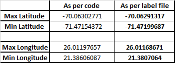
Hi June, Hope you are fine. Thanks for the suggestions. Using y = ( L0 – Line-1) * Scale Central Latitude = -70.8 degree Equation 20-15 for longitude calculation LINE_PROJECTION_OFFSET = 4476 Also, ignored the no data region for calculation (that is took sample = 1 for first data not in NODATA region) for each line. Moreover line = 1 is the line corresponding to the first line which has a pixel that is not in NODATA region. This has given good results for the latitude (obtained Lat range -71.4527 to -70.0472) but they still do not match exactly with expected latitude range of ( -70.06291 to -71. 47199). Longitude range obtained is 21.2084 to 25.46 (Against 21.38 to 26.011) . Maybe, once you get proper line projection offset value from the data provider, the result would match exactly. Ayushman
-
I have downloaded an LRO NAC mosaic of Vikram landing site (November image, 5m resolution) image from the following link http://wms.lroc.asu.edu/lroc/view_rdr_product/NAC_ROI_VIKRAM__LOC_P708S0237_5M I am trying to calculate and store the latitude and longitude coordinates for all the pixels in the mosaic into an array. As pointed in the 2nd point in the response below by Miss Wang, there appears to be a discrepancy in the LINE PROJECTION OFFSET value mentioned in the PDS label for the dataset. https://geoweb.rsl.wustl.edu/community/index.php?/topic/2804-details-needed-for-lroc-nac-mosaic-img-file/&do=findComment&comment=4621" "The LINE_PROJECTION_OFFSET value in the label doesn’t match with the value of CENTER_LATITUDE. Need to check with the data provider to see what the value used in their processing pipelines" Can you please let me know the correct LINE PROJECTION OFFSET value to be used for calculating Lat /Long values. Thanks Ayushman
-
Hi June, Please find attached my MATLAB code . MATLAB's .m file extension is not supported and hence I am attaching a .txt version of the same. Kindly let me know if you need any more details. Thanks Ayushman mosaic_long_lat_store_code.txt
-
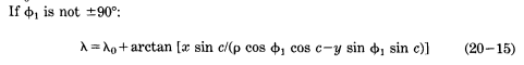
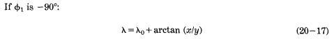
Hi June, Thanks a lot for resolving the queries. However, on going through the chapter on stereo graphic projections in the reference book “Snyder, J. P. (1987). Map Projections: A Working Manual", I have some more queries related to the value of Lat P and the expression to be used for Latitude/Longitude calculation. For LatP not equal to + or - 90 degrees , longitude is to be calculated as given in equation number => 20-15. However, an equation similar to the above equation can't even be found in the DSMAP.CAT file. Secondly equation 20-17 which is found in the DSMAP.CAT file to calculate the longitude can only be used for the case where LatP is -90 degrees Does the above suggest that for Polar Stereographic projection in moon's southern hemisphere we always have to take LatP = -90 degrees which was mentioned in the DSMAP.CAT file earlier and not the one to be used in the label file. I have tried with different combinations of Lat P and Lat/ Long expressions. The results obtained are attached in the excel file. I have not been able to replicate the results for Lat/Long ranges which are mentioned in the label file.Results are calculated using C = 2* ARCTAN[P/(2*Rp)] as pointed by you in the previous post. (Case 4) LatP = -90 degrees gives the best result. However the Latitude ranges are quite different from expected while Longitude range is much closer to the expected values but still different. Surprisingly (Case 2, LatP = -90 degrees) also gives decent result even though the expression used for calculating longitude is one which is reserved for case of LatP not equal to + or - 90 degrees. In any case LatP = -70.8 degrees (value mentioned in the label) doesn't give appropriate result. Kindly clarify. Please let me know of any discrepancies that may exist in the equations for calculating the Latitude and Longitude. Let me know if you need any other details from my side to resolve the issues. Thanks a lot for your patience. Ayushman results_calculated_using_different_LatP_and_Longitude_expressions.xlsx
-
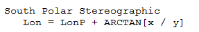
Thanks June for your reply. I downloaded the DSMAP.CAT file and also was able to access the label of the file. However, I still am not getting proper Latitude values and need certain clarifications with regard to the equations mentioned for obtaining Lat,Long coordinates. In polar stereo graphic projection section it is mentioned that P = SQRT(x^2 + y^2) ; C = 2 * ARCTAN(P / 2 * Rp) Just wanted to confirm if C = 2* ARCTAN[(P*Rp)/2] and not C = 2* ARCTAN[P/(2*Rp)] Secondly, it is mentioned that where LonP is the central longitude, LatP is the latitude of true scale and is always 90 or -90. However in the same section we have LatP defined to be equal to the CENTER_LATITUDE in the PDS Label. When I looked up the label, I found out that the CENTER_LATITUDE mentioned is not -90 but -70.8. Which of the 2 definitions should one take for calculation ?? Ayushman
-
Location coordinates needed for LRO NAC CDR images
ayushman replied to ayushman's topic in For data users
Thanks June for your reply. I will check these links. -
Location coordinates needed for LRO NAC CDR images
ayushman replied to ayushman's topic in For data users
Hi June, Thanks a lot for your reply. I am not familiar with ArcMap or any other GIS tool and am using MATLAB. I wanted to know if it's possible to store the actual Latitude and Longitude coordinates for each pixel in an array or an excel file using ArcMap or any other freely available GIS tool ? Ayushman -
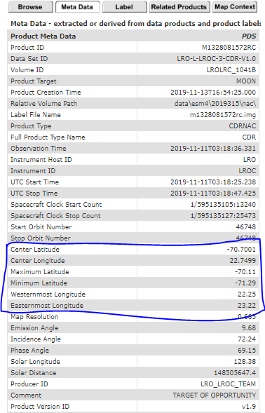
Hello all, I have downloaded the following LROC NAC CDR files from the Lunar Orbital Data Explorer Node https://ode.rsl.wustl.edu/moon/indexproductsearch.aspx M1328074531LC M1328074531RC M1328081572LC M1328081572RC M1328088614LC M1328088614RC I need to know the latitude and longitude coordinates corresponding to each of the 52224*5000 pixels. The meta data section corresponding to the results on the above link only lists the center and extreme latitude/longitude coordinates. Kindly let me know how to proceed forward. Thanks Ayushman
-
Hello all, I have downloaded an LRO NAC mosaic of the Vikram Landing site(November image) from the following link - http://wms.lroc.asu.edu/lroc/view_rdr_product/NAC_ROI_VIKRAM__LOC_P708S0237_5M I am trying to read the image(.IMG file) on MATLAB and need the following information for subsequent analysis- I couldn't find any label file for the .IMG file and was facing difficulty in reading the data. If it exists, can someone guide me to the link. Is there any way in which I can find out the actual latitude and longitude coordinate of each pixel in the mosaic. The link above for the site only tells the Lat/Long coordinates for the extremes. Also, does the westernmost longitude correspond to the left side of the mosaic and the maximum latitude correspond to the top of mosaic ? Thanks Ayushman