June Wang
-
Posts
575 -
Joined
-
Last visited
Content Type
Profiles
Forums
Downloads
Blogs
Everything posted by June Wang
-
No-data area will not change the line and sample value of each pixel in the data. So the data will still start from (1,1) for the top-left corner. All you need is just ignore those no-data pixels in your calculation without changing the line and sample values.
-
One more finding is if using the function of “y = (1 - L0 - Line) * Scale” in line 128 of ‘DSMAP.CAT’ file, y value will always be negative with current label value input, which doesn’t match with the real y value in the data. It looks to me this equation could be changed to “y = ( L0 – Line-1) * Scale”. You can try LINE_PROJECTION_OFFSET = 4476. This value is just my guess, may not be correct. I have contacted with the data provider. I will post the final solution here when I hear anything back from the data provider’s.
-
Details needed for LROC NAC mosaic .IMG file
June Wang replied to ayushman's topic in For data users
Hi Ayushman, Two things here. In your code, you looped around all the pixels. Please don’t include the nodata area in your calculation. The LINE_PROJECTION_OFFSET value in the label doesn’t match with the value of CENTER_LATITUDE. Need to check with the data provider to see what the value used in their processing pipelines. Thanks, June -
October 9, 2020 – MRO HiRISE Updates - MRO HiRISE EDR, RDR, DTM and Anaglyph data products released through September 1, 2020 (Orbit 66099) See https://ode.rsl.wustl.edu/odeholdings/Mars_holdings.html
-
Details needed for LROC NAC mosaic .IMG file
June Wang replied to ayushman's topic in For data users
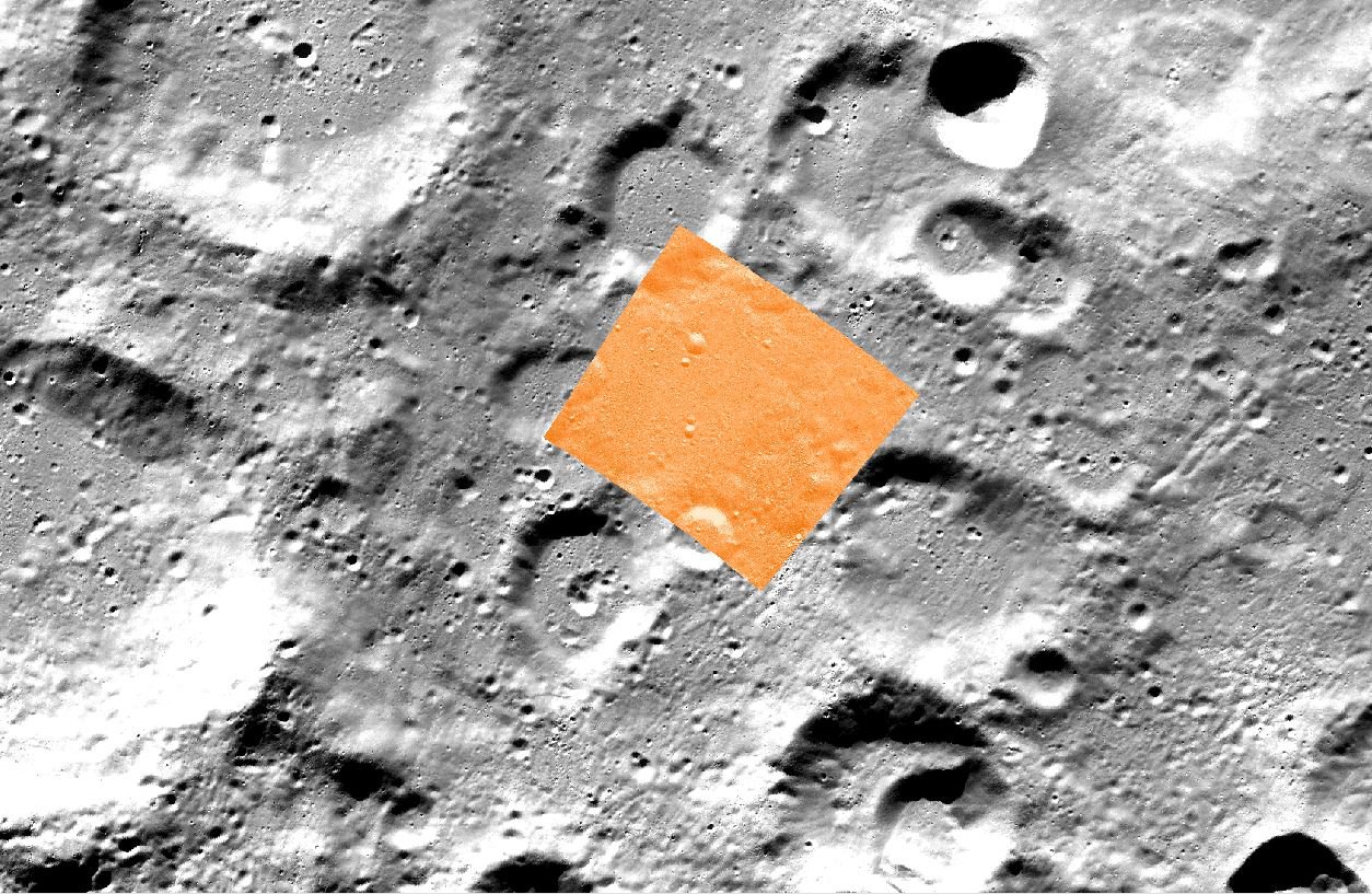
Hi Ayushman, Attached is the screen capture of the LROC RDR (orange color, NAC_ROI_VIKRAM__LOC_P708S0237_5M.TIF) overlain on a WAC mosaic near the South Pole area together with its spatial reference information. The feature matches well. If everything is correct in the book, it looks to me equation 20-15 is a better fit for this case. Have you checked other parameters or steps in your calculation? If you can send me your code and your original value input for the calculation, I can take a further look. Thanks, June
-
Details needed for LROC NAC mosaic .IMG file
June Wang replied to ayushman's topic in For data users
Hi Ayushman, Question 1-> It looks to me C = 2* ARCTAN[P/(2*Rp)] is correct, when compared this with the equation (21-15) in book page 159 of the book “Snyder, J. P. (1987). Map Projections: A Working Manual. U.S. Geological Survey Professional Paper 1395. Washington, DC: United States Government Printing Office.” Please let me know if this is not correct to your test. Question 2-> Please use the value in the attached label. The sentence written in the DSMAP.CAT is more like a general case. Thanks, June -
Details needed for LROC NAC mosaic .IMG file
June Wang replied to ayushman's topic in For data users
Hi Ayushman, To get the lat&lon for each pixel of the LROC map projected RDRs, please read the ‘DSMAP.CAT’ at https://pds.lroc.asu.edu/data/LRO-L-LROC-5-RDR-V1.0/LROLRC_2001/CATALOG/, which gives the equations and steps on how to convert image array coordinates (Sample, Line) to map coordinates (x, y), and then from map coordinates (x, y) to planetocentric coordinates (Lat, Lon) for different kind of projections. All the parameters needed for the calculation could be find in the attached label of this product. Please let me know if you need more information. Thanks, June -
Location coordinates needed for LRO NAC CDR images
June Wang replied to ayushman's topic in For data users
Hi Ayushman, Sorry, these are LROC NAC CDR data products. They are not map projected, but you can still use Arcmap and Gdal to read the data. I confused them with the LROC RDR data in your other post at https://geoweb.rsl.wustl.edu/community/index.php?/topic/2804-details-needed-for-lroc-nac-mosaic-img-file/&tab=comments#comment-4594. I will keep a post there on how to get the lat&lon for each pixel of the LROC map projected RDRs. In the index table under INDEX directory of the LROC CDR volumes, e.g., https://pds.lroc.asu.edu/data/LRO-L-LROC-3-CDR-V1.0/LROLRC_10**/INDEX/, you will find the lat&lon coordinates of the center point and 4 corner points. If you want to get the lat&lon for each pixel in the image, you will probably need to try the NAIF SPICE tools https://naif.jpl.nasa.gov/naif/toolkit.html or USGS ISIS https://isis.astrogeology.usgs.gov/index.html to see if they have function for this. Thanks, June -
October 6th, 2020 - New MEX OMEGA EDR Data Loaded into ODE - Updated MEX OMEGA EDR data products for extended mission 7 released through December 22nd, 2019 (Orbit 20196). See https://ode.rsl.wustl.edu/odeholdings/Mars_holdings.html
-
Location coordinates needed for LRO NAC CDR images
June Wang replied to ayushman's topic in For data users
Hi Ayushman, You can use gdal_translate command from gdal tool to translate the img data into a Geotiff, and use this Geotiff in any GIS tools. Arcmap can read the PDS IMG data directly with all its spatial reference information. The version I used here is an old one 10.2.2. Higher version should also work. June -
Details needed for LROC NAC mosaic .IMG file
June Wang replied to ayushman's topic in For data users
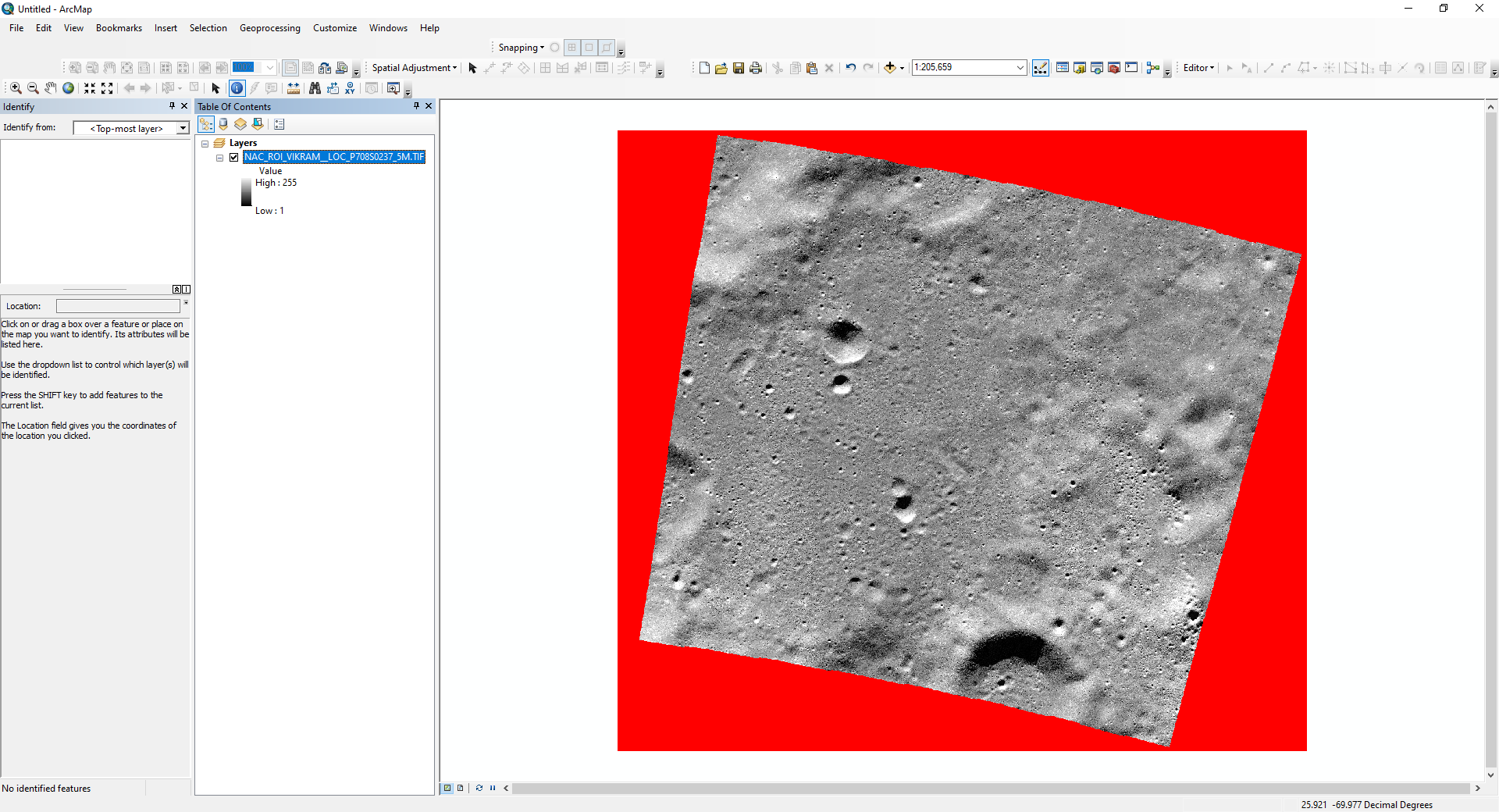
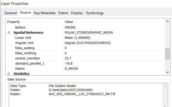
Hi Ayushman, This LROC IMG data has an attached label. You can view the label content with UltraEdit or a Nodepad tool. From the link you gave above, you can also download the Geotiff image from Extra Downloads box. When adding this Geotiff in Arcmap and moving you mouse on the image, you can see the coordinates of each pixel. Because this product is in Polar Stereographic projection, the default coordinates display is in meters. You can change the map setting to view the coordinates in degrees. Since this data including NoData, the red part as shown below, the westernmost longitude is not the left side of the mosaic and the maximum latitude doesn't correspond to the top of mosaic. Please let me know if you need more help. Thanks, June
-
October 2nd, 2020 - Mars Odyssey Release 73 Data Updates Loaded NS and HEND raw and derived data into ODE through April 9th, 2020 Updated THEMIS standard data products (IREDR, IRRDR, IRBTR, VISEDR, VISRDR and VISABR data) from February 19th, 2002 to March 2nd, 2020 Updated THEMIS geometry data products (IRGEO2, IRPBT2, VGEO2, and VISALB data) from September 28th, 2013 to March 2nd, 2020 See https://ode.rsl.wustl.edu/odeholdings/Mars_holdings.html FYI – THEMIS team have some important electrical work that needs to be done on their building this weekend. Most likely all of their servers will be unavailable from Friday, Oct 2 (6pm AZ) through Monday, Oct 5 (6am AZ).
-
September 28th, 2020 Updated LROC RDR data products with version 0057 for this release. Updated Diviner RDR query tool database from July 5th, 2009 to June 16th, 2020.
-
September 22nd, 2020 - LRO Release 43 has been loaded into ODE. Updated LAMP EDR and RDR products from July 6th, 2009 to June 15th, 2020 Updated LEND EDR_SCI, EDR_HK, RDR_RSCI, and RDR_CHK products from June 18th, 2009 to June 14th, 2020 Updated LEND RDR_DLD and RDR_DLX products from June 27th, 2009 to March 14th, 2020 Updated Diviner EDR and RDR products from July 5th, 2009 to June 16th, 2020 Updated LROC EDR and CDR products from June 30th, 2009 to June 16th, 2020 Updated Mini-RF Version 3 Bistatic radar data products (EDR, RDR, and DDR) from January 28th, 2019 to October 27th, 2019 Updated LOLA EDR products from June 18th, 2009 to July 16th, 2020 Updated LOLA RDR products from July 13th, 2009 to July 16th, 2020. Updated LOLA RDR query tool database from July 13th, 2009 to July 16th, 2020 In Progress LROC RDR products for this release, which has a reorganized directory structure as well as improved documentation, and PNG browse images for all pyramidal tiffs based on reviewer feedback. Please see more information at http://pds.lroc.asu.edu/data/LRO-L-LROC-5-RDR-V1.0/LROLRC_2001/ERRATA.TXT In Progress Diviner RDR query tool database from July 5th, 2009 to June 16th, 2020 Please see ODE Lunar Holdings - https://ode.rsl.wustl.edu/odeholdings/Moon_holdings.html
-
September 9th, 2020 - New MEX OMEGA EDR Data Loaded into ODE - Updated MEX OMEGA EDR data products for extended mission 7 released through June 30th, 2019 (Orbit 19597). See https://ode.rsl.wustl.edu/odeholdings/Mars_holdings.html
-
September 3rd, 2020 - MRO Release 54 Loaded into ODE. - Updated MRO CRISM EDR and CDR products from September 27th, 2006 to May 9th, 2020 - Updated MRO CRISM DDR products from September 27th, 2006 to May 8th, 2020 - Updated MRO CRISM TRDR products from September 27th, 2006 to May 8th, 2020 - Updated MRO raw gravity data products released through August 3rd, 2020 - Updated SHARAD Radargram data products released through February 8th, 2020 (orbits through 63455) - Updated MRO MCS EDR, RDR and DDR products from September 15th, 2006 to April 30th, 2020 - Updated MRO CTX EDR products from August 30th, 2006 to March 1st, 2020 - Updated MRO HiRISE EDR, RDR, DTM and anaglyph products released through July 18th (Orbit 65521), 2020 Please see ODE Mars Holdings – https://ode.rsl.wustl.edu/odeholdings/Mars_holdings.html
-
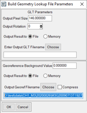
Fig. 1 is correct. In fig.1, you used the Sample Transverse Mercator. I noticed it is a default projection template string in map_proj.txt in ENVI. Since you already edited the radius in the template string. It is OK to use it. But you could also copy this template and make changes to the parameters and projection name as you need it. In Fig. 2, you can output GeorefFilename to the directory you like and keep other default settings, then click ok. You can refer to the file "Instruction to work with M3 level2 data.pdf" posted on November 14, 2019 in the above. BTW, WAC mosaics can be downloaded from http://wms.lroc.asu.edu/lroc/view_rdr/WAC_GLOBAL Please let me know if you need more help. Thanks, June
-
All your three files look good to me. I downloaded the data and tried the Georeference from IGM, and projected the data using your projection string. It took more than 1 hour for all the process to be finished. The results look good when compared with a LROC basemap. If you can send me more details where you stuck in I can help you from there. Thanks, June
-
August 7, 2020 – MRO HiRISE Updates in Mars ODE - Loaded MRO HiRISE EDR, RDR, DTM and Anaglyph data products released through July 1, 2020 (Orbit 65,299) See https://ode.rsl.wustl.edu/odeholdings/Mars_holdings.html
-
August 3rd, 2020 Release 14 of MRO CRISM MTRDR (Map-projected Targeted Reduced Data Record), TER (Targeted Empirical Record), and TRDR (Targeted Reduced Data Record) browse and extras data has been loaded into ODE. This release fills in data from 2008_018 through 2008_221. See https://wufs.wustl.edu/ode/odeholdings/Mars_holdings.html for more information.
-
July 16th, 2020 Loaded a new Diviner data product type, Polar Cumulative Products (PCPs) into ODE. See ERRATA.TXT for details.
-
July 3rd, 2020 - Mars Odyssey Release 72 Data Updates Loaded NS and HEND raw and derived data into ODE through Jan 14th, 2020 Updated THEMIS standard data products (IREDR, IRRDR, IRBTR, VISEDR, VISRDR and VISABR data) from February 19th, 2002 to December 2nd, 2019 Updated THEMIS geometry data products (IRGEO2, IRPBT2, VGEO2, and VISALB data) from September 28th, 2013 to December 2nd, 2019 See https://wufs.wustl.edu/ode/odeholdings/Mars_holdings.html.
-
July 3, 2020 – MRO HiRISE Updates - MRO HiRISE EDR, RDR, DTM and Anaglyph data products released through May30, 2020 (Orbit 64,899) See https://wufs.wustl.edu/ode/odeholdings/Mars_holdings.html
-
July 1st, 2020 Updated Diviner RDR query tool database from July 5th, 2009 to March 16th, 2020
-
June 27th, 2020 – - Updated delayed MRO SHARAD EDR and RDR products from ASI for MRO Release 53, with coverage from August 18 through November 9, 2019 (orbits through 62283) - Updated backlogged SHARAD RDRs from ASI from previous MRO Releases 50 and 51, with coverage from November 9, 2018, through May 8, 2019. This completes the backlog.