June Wang
-
Posts
575 -
Joined
-
Last visited
Content Type
Profiles
Forums
Downloads
Blogs
Everything posted by June Wang
-
Sorry, my bad. It is int16.
-
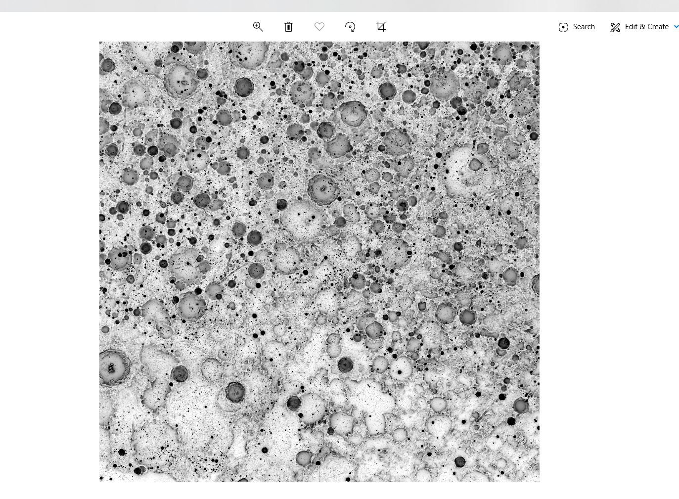
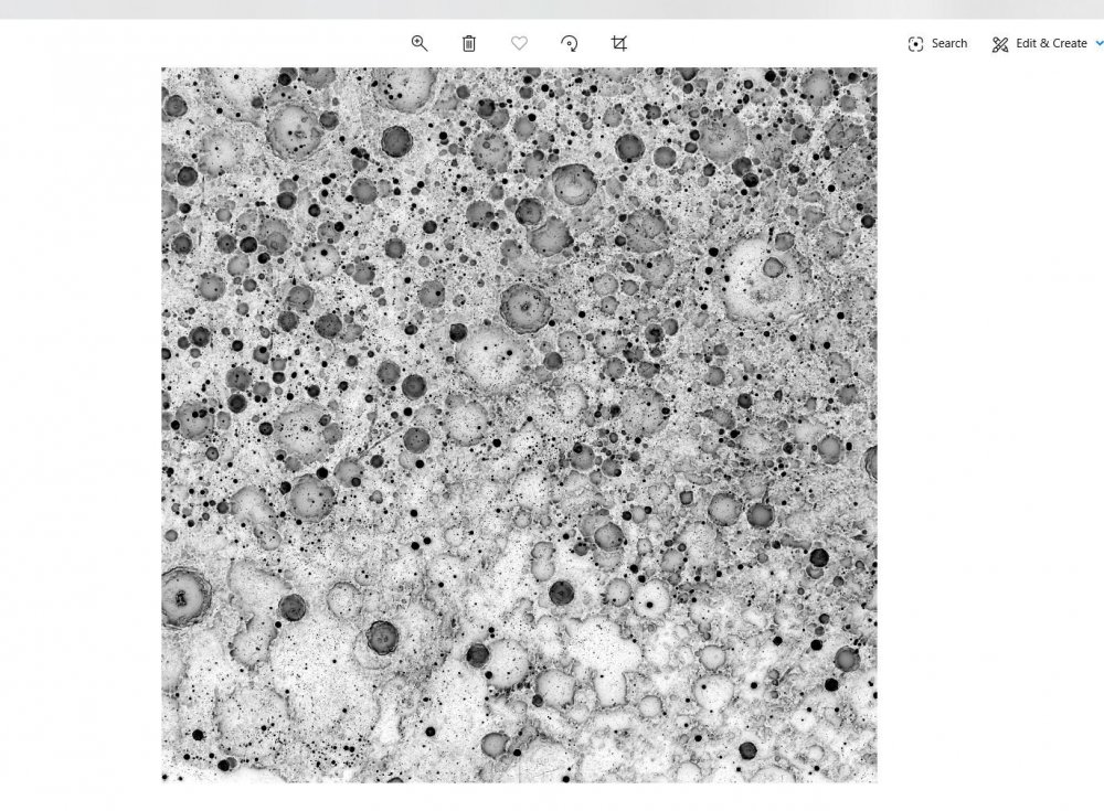
Hi, Try to read the IMG as UInt16 LSB type. This may solve your problem. I haven't try the IMG data with MATLAB, but I could read them with c# codes. Below is some hint when I read the IMG with C#. - read the img as binary - convert the binary data to the right format int numPixels = nColumns * nRows * nBands; var img = new UInt16[numPixels]; Byte[] myBytesReordered = new Byte[2]; for (int i = 0; i < numPixels; i++) { int byteImgId = i * 2; myBytesReordered[0] = data[byteImgId]; myBytesReordered[1] = data[byteImgId + 1]; img = BitConverter.ToUInt16(myBytesReordered, 0); } Attached is the screen capture of my result with 2% linear stretch. Please let me know if you need more help. Thanks, June
-
June 20th, 2020 - LRO Release 42 has been loaded into ODE. Updated LAMP EDR and RDR products from July 6th, 2009 to March 14th, 2020 Updated LEND EDR_SCI, EDR_HK, RDR_RSCI, and RDR_CHK products from June 18th, 2009 to March 14th, 2020 Updated LEND RDR_DLD and RDR_DLX products from June 27th, 2009 to December 14th, 2019 Updated Diviner EDR and RDR products from July 5th, 2009 to March 16th, 2020 Updated LROC EDR, CDR and RDR products from June 30th, 2009 to March 15th, 2020 Loaded Mini-RF new Version 3 Bistatic radar data products (EDR, RDR, and DDR) from January 28th, 2019 to September 29th, 2019 Updated LOLA EDR products from June 18th, 2009 to April 28th, 2020 Updated LOLA RDR products from July 13th, 2009 to April 28th, 2020 Updated LOLA RDR query tool database from July 13th, 2009 to April 28th, 2020 In Progress Diviner RDR query tool database from July 5th, 2009 to March 16th, 2020 Please see ODE Lunar Holdings - https://wufs.wustl.edu/ode/odeholdings/Moon_holdings.html
-
June 5th, 2020 - MRO Release 53 Loaded into ODE. - Updated MRO CRISM EDR and CDR products from September 27th, 2006 to February 9th, 2020 - Updated MRO CRISM DDR products from September 27th, 2006 to February 8th, 2020 - Updated MRO CRISM TRDR products from September 27th, 2006 to February 8th, 2020 - Updated MRO raw gravity data products released through May 3rd, 2020 - Updated SHARAD Radargram data products released through November 18th, 2019 (orbits through 62399) - Updated MRO MCS EDR, RDR and DDR products from September 15th, 2006 to January 31st, 2020 - Updated MRO CTX EDR products from August 30th, 2006 to December 1st, 2019 - Updated MRO HiRISE EDR, RDR, and anaglyph products released through April 30th (Orbit 64499), 2020 Please see ODE Mars Holdings – https://wufs.wustl.edu/ode/odeholdings/Mars_holdings.html
-
May 19th, 2020 - MEX HRSC new Version 3 map projected data (REFDR3) data have been loaded into ODE - HRSC new Version 3 of map projected RDR data (REFDR3) have been loaded into ODE, with coverage through June 29, 2019 (Orbit 10-19592). See https://wufs.wustl.edu/ode/odeholdings/Mars_holdings.html for a full list of data holdings in ODE.
-
May 8, 2020 – MRO HiRISE Updates - MRO HiRISE EDR, RDR, DTM and Anaglyph data products released through April 6, 2020 (Orbit 64,199) See https://wufs.wustl.edu/ode/odeholdings/Mars_holdings.html
-
May 3rd, 2020 - More MEX HRSC RDR Version 3 and HRSC new Version 3 map projected data (REFDR3) data Loaded into ODE - HRSC new radiometrically calibrated (RDR version 3) image data have been loaded into ODE, with coverage through June 29th, 2019 (Orbit 10-19592). - HRSC new Version 3 of map projected RDR data (REFDR3) have been loaded into ODE, with coverage through February 4th, 2019 (Orbit 10-19093). See https://wufs.wustl.edu/ode/odeholdings/Mars_holdings.html
-
April 23, 2020 36 revised Diviner GDR data products have been loaded into ODE. Please see ERRATA.TXT (https://pds-geosciences.wustl.edu/lro/lro-l-dlre-4-rdr-v1/lrodlr_1001/errata.txt) for more details.
-
April 22nd, 2020 - More MEX HRSC RDR Version 3 data and HRSC new Version 3 map projected data (REFDR3) Loaded into ODE - HRSC new radiometrically calibrated (RDR version 3) image data have been loaded into ODE, with coverage through April 4th, 2019 (Orbit 10-19298). - HRSC new Version 3 of map projected RDR data (REFDR3) have been loaded into ODE, with coverage through December 31st, 2018 (Orbit 10-18975). See https://wufs.wustl.edu/ode/odeholdings/Mars_holdings.html
-
April 16th, 2020 - MRO SHARAD RDR (ASI) backlogged data for releases 48-49, as well as some missing RDRs from release 47 loaded into ODE SHARAD RDRs from ASI have been loaded into ODE for previous MRO releases 48-49, as well as some missing RDRs from release 47. These new data cover the periods April 21 through October 15, 2018. See file ERRATA.TXT at https://pds-geosciences.wustl.edu/mro/mro-m-sharad-4-rdr-v1/mrosh_1004/errata.txt for more details. Please see ODE Mars Holdings – https://wufs.wustl.edu/ode/odeholdings/Mars_holdings.html.
-
April 3rd, 2020 - New MEX OMEGA EDR Data Loaded into ODE - Updated MEX OMEGA EDR data products for extended mission 6 and extended mission 7 released through June 2nd, 2019 (Orbit 19498). See https://wufs.wustl.edu/ode/odeholdings/Mars_holdings.html
-
April 3, 2020 – MRO HiRISE Updates - MRO HiRISE EDR, RDR, and DTM data products released through March 6, 2020 (Orbit 63,799) See https://wufs.wustl.edu/ode/odeholdings/Mars_holdings.html
-
April 1st, 2020 - Mars Odyssey Release 71 Data Updates Loaded NS and HEND raw and derived data (EDR, DHD, DND, AHD, and AND) into ODE through October 8th, 2019 Updated THEMIS standard data products (IREDR, IRRDR, IRBTR, VISEDR, VISRDR and VISABR data) from February 19th, 2002 to September 3rd, 2019 Updated THEMIS geometry data products (IRGEO2, IRPBT2, VGEO2, and VISALB data) from September 28th, 2013 to September 3rd, 2019 See https://wufs.wustl.edu/ode/odeholdings/Mars_holdings.html.
-
April 1st, 2020 - MEX HRSC new Version 3 map projected data (REFDR3) data have been loaded into ODE - HRSC new Version 3 of map projected RDR data (REFDR3) have been loaded into ODE, with coverage through November 10, 2018 (Orbit 10-18798). See https://wufs.wustl.edu/ode/odeholdings/Mars_holdings.html for a full list of data holdings in ODE.
-
March 20th, 2020 - LRO Release 41 has been loaded into ODE. Updated LAMP EDR and RDR products from July 6th, 2009 to December 15th, 2019 Updated LEND EDR_SCI, EDR_HK, RDR_RSCI, and RDR_CHK products from June 18th, 2009 to December 14th, 2019 Updated LEND RDR_DLD and RDR_DLX products from June 27th, 2009 to September 14th, 2019 Updated Diviner EDR and RDR products from July 5th, 2009 to December 16th, 2019 Updated LROC EDR, CDR and RDR products from June 30th, 2009 to December 3rd, 2019 Loaded Mini-RF new Version 3 Bistatic radar data products (EDR, RDR, and DDR) from January 28th, 2019 to June 13th, 2019 Updated LOLA EDR products from June 18th, 2009 to January 22nd, 2020 Updated LOLA RDR products from July 13th, 2009 to January 22nd, 2020 Updated LOLA RDR query tool database from July 13th, 2009 to January 22nd, 2020 Updated Diviner RDR query tool database from July 5th, 2009 to December 16th, 2019 Please see ODE Lunar Holdings - https://wufs.wustl.edu/ode/odeholdings/Moon_holdings.html
-
March 19th, 2020 - Updated MRO SHARAD EDR and RDR products from ASI for MRO Release 52 through August 17th, 2019 (orbits through 61208)
-
March 3rd, 2020 - MRO Release 52 Loaded into ODE. - Updated MRO CRISM EDR and CDR products from September 27th, 2006 to November 9th, 2019 - Updated MRO CRISM DDR products from September 27th, 2006 to November 8th, 2019 - Updated MRO CRISM TRDR products from September 27th, 2006 to November 8th, 2019 - Updated MRO raw gravity data products released through October 26th, 2019 - Updated SHARAD Radargram data products released through August 9th, 2019 (orbits through 61097) - Updated MRO MCS EDR, RDR and DDR products from September 15th, 2006 to October 31st, 2019 - Updated MRO CTX EDR products from August 30th, 2006 to August 21st, 2019 - Updated MRO HiRISE EDR, RDR, anaglyph and DTM products released through February 4th (Orbit 63399), 2020 Please see ODE Mars Holdings – https://wufs.wustl.edu/ode/odeholdings/Mars_holdings.html
-
March 3rd, 2020 - MEX HRSC new Version 3 map projected data (REFDR3) data have been loaded into ODE - HRSC new Version 3 of map projected RDR data (REFDR3) have been loaded into ODE, with coverage through September 11, 2018 (Orbit 10-18594). See https://wufs.wustl.edu/ode/odeholdings/Mars_holdings.html for a full list of data holdings in ODE.
-
February 19, 2020 A new Mercury SHBDR gravity model derived from MESSENGER radio science data are loaded into ODE. Please see below links for more information. https://pds-geosciences.wustl.edu/missions/messenger/rs.htm ODE Mercury Holdings - https://wufs.wustl.edu/ode/odeholdings/Mercury_holdings.html
-
February 19th, 2020 - MRO SHARAD RDR (ASI) backlogged data for releases 36-47 loaded into ODE MRO SHARAD derived data from the ASI (Italian Space Agency) SHARAD Ground Operations Center released covering the period May 17, 2015 - April 20, 2018 have been loaded into ODE. These time periods correspond to previous MRO releases 36-47. The SHARAD team is recovering data from deliveries that were missed due to a hiatus in ground operations between June 2012 and March 2013. See file ERRATA.TXT at https://pds-geosciences.wustl.edu/mro/mro-m-sharad-4-rdr-v1/mrosh_1004/errata.txt for more details. Please see ODE Mars Holdings – https://wufs.wustl.edu/ode/odeholdings/Mars_holdings.html
-
February 7, 2020 – MRO HiRISE Updates - MRO HiRISE EDR, RDR, DTM and Anaglyph newly released data products through January 4, 2020 (Orbit 62,999) loaded into ODE See https://wufs.wustl.edu/ode/odeholdings/Mars_holdings.html
-
January 10, 2020 – MRO HiRISE Updates - MRO HiRISE EDR, RDR, DTM and Anaglyph data products released through December 3, 2019 (Orbit 62,599) See https://wufs.wustl.edu/ode/odeholdings/Mars_holdings.html
-
Along-track stripping artifact correction and map projection
June Wang replied to Wladimir Acevedo's topic in For data users
Did you try to use ENVI mask or band calculation to filter out the black pixels? If you like, you can upload the CRISM output together with the ENVI header online. I can have a try of your data. Thanks, June -
Along-track stripping artifact correction and map projection
June Wang replied to Wladimir Acevedo's topic in For data users
Do you mean the black pixels along the edge of the image, which represent no data? If that is the "black pixels" you want to clean, in ArcGIS, when you overlain the CRISM output onto a DTM, right click the image, and choose properties. Below is the instruction to remove the background area of a raster layer using the Unique Values renderer in ArcMap. Arcscene has similar function to set the background color as transparent. Or you can google an example. I cannot use ArcGIS desktop these days due to a university license issue. People are still working on that. If you still have problem, I can send you a pic example as soon as I can access my ArcGIS desktop again. Thanks, https://desktop.arcgis.com/en/arcmap/10.3/manage-data/raster-and-images/removing-the-background-using-the-unique-values-renderer.htm June -
Along-track stripping artifact correction and map projection
June Wang replied to Wladimir Acevedo's topic in For data users
I am not quite understand your question. Do you like to know how to give a 3D view? I saw your overlain of the CRISM onto a CTX. If you overlain all the images onto a DTM, and change the terrain exaggeration factors, you will see something like above figures from different points of views. HiRiSE DTM has much higher resolution than the DTMs from HRSC and MOLA. Map resolution for a HiRISE image is about 25cm/pixel, and the HiRISE DTM is about 1m/pixel. HRSC DTMs have various resolution from 50m/pixel to 400m/pixel. Most of the products are at the resolution of ~50m/pixel, 75m/pixel, and 100m/pixel. MOLA DTM is about 500m/pixel. CTX image is about 6m/pixel. And FRT CRISM data are about 18m/pixel. Depending on your needs, the higher resolution of a DTM, the more detailed features the terrain can represent.